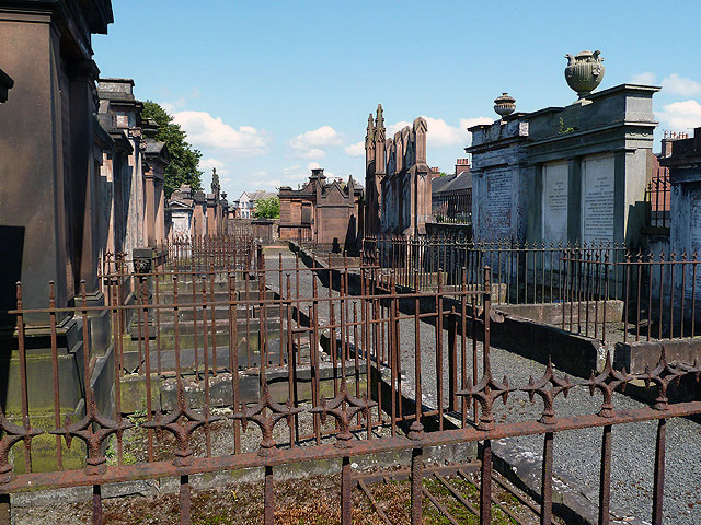
Image: St Michael’s and Holy Cross Churchyards by Walter Baxter, sourced from Wikimedia Commons and licensed under CC BY-SA 2.0.

Dumfries’s principal historic burial landscape combines an imposing watch-house gateway, exceptional eighteenth- and nineteenth-century monuments, epidemic memory, the Burns Mausoleum and continuing cemetery use.
Quick facts
- Date
- Monuments principally seventeenth to nineteenth century; main gate probably mid-eighteenth century
- Architect / designer
- Many makers, including Walter Newall; individual architects are not always identified
- Type
- Historic churchyard enclosures with monumental gates, watch houses, mausoleum and major memorial groups
- Designation
- Listed building, Category A (LB26336)
- OS grid reference
- NX 97545 75699
A burial landscape, not a single monument
The designation covers an irregular enclosure around St Michael’s Church, together with Holy Cross Churchyard. Rubble boundary walls frame a dense landscape of upright gravestones, mural memorials, obelisks, family monuments and enclosed burial areas. At the north-west entrance, tall painted-ashlar gatepiers are articulated with pilasters and urn finials. Watch houses are incorporated into the gateway, while wrought-iron gates and an overthrow turn a point of practical control into a ceremonial entrance.
The monuments vary greatly in date and ambition. Historic Environment Scotland singles out the vigorous baroque Sharp of Hoddom monument of about 1710, restored in 1894; martyr memorials; a granite obelisk of 1834 inscribed “A Newall”; and Hood family monuments by the Dumfries architect Walter Newall. The Burns Mausoleum, the cholera enclosure, Holy Cross burial ground and the remains of its chapel add distinct layers to the larger landscape.
Its story
Burial and commemoration accumulated around St Michael’s over centuries rather than through one planned campaign. The gate’s watch houses recall the period when burial grounds were guarded against disturbance and body-snatching. Monument types record changing ideas of family, faith and public memory, from upright stones and mural tablets to obelisks and mausoleums.
The listing also points to the nineteenth-century attention paid to Dumfries as a centre of cemetery design and stone-carving. J. C. Loudon compared the town’s upright monuments with those of Glasgow and Edinburgh and noted that local makers advertised both their monuments and the freight charges for sending them elsewhere. The churchyards therefore preserve evidence of a regional craft economy as well as individual lives.
Why it is included
Category A recognises the exceptional concentration and quality of the monuments, the architectural gateway and watch houses, and the way the ensemble brings together religion, civic identity, public health, literary memory and local stone-working. Its significance lies in the whole layered landscape; no single map point can represent every grave, structure or boundary.
What to notice
- The urn-finialled gatepiers, ironwork and watch houses at the principal entrance.
- The exuberant baroque form of the Sharp of Hoddom monument.
- The contrast between upright stones, mural monuments, obelisks and mausoleums.
- The separate identities of the cholera enclosure, Burns Mausoleum and Holy Cross area.
- Lettering, carving and stone types that reveal different dates, makers and commemorative ambitions.
Visiting respectfully
Dumfries and Galloway Council’s 2024–2034 strategy identifies St Michael’s Churchyard and Cemetery as an active burial ground; its capacity figures are a planning estimate, not a visitor timetable. No authoritative daily opening hours are published in the sources used here. Public appreciation is therefore described cautiously as access to the churchyard paths when the gates are open, subject to funerals, maintenance, wall repairs and any on-site closure notice.
This remains a place of burial and remembrance. Give mourners and funeral parties priority, keep to established paths, do not climb on or touch monuments, and supervise children and dogs. Old surfaces, grass, slopes and closely spaced stones can be uneven; the record does not claim a uniformly step-free route through the historic enclosure.
Timeline
- About 1710 The Sharp of Hoddom monument dates from this period.
- Probably mid-eighteenth century The monumental main gate and incorporated watch houses were formed.
- 1834 A granite obelisk inscribed “A Newall” was erected.
- 1894 The Sharp of Hoddom monument was restored.
- 2024–2034 strategy period The council continues to identify St Michael’s as an active cemetery and to plan for capacity and fabric maintenance.
What we know — and what remains uncertain
The statutory account identifies the principal architectural groups but is not a complete inventory of every grave or maker. Individual attributions, inscriptions and conditions need monument-level checking. The mapped point locates a large irregular enclosure; it should not be treated as the position of a particular burial plot or as a legal boundary survey.
Sources & further reading
- Historic Environment Scotland: St Michael’s Churchyard and Main Gate and Holy Cross Churchyard, LB26336 — designation, extent, gateway, monument groups, makers and statement of interest.
- Dumfries and Galloway Council: Burial Ground Strategy 2024–2034 — council operation, active-cemetery status and capacity planning.
- Dumfries and Galloway Council: Public Realm Capital Programme 2024–25 — recent boundary-wall repair programme for St Michael’s cemetery and churchyard.
Location
OS grid reference NX 97545 75699 · Location confidence: High: the statutory designation supplies a mapped National Grid Reference and a current official operator, responsible public body or institutional source confirms the Place relationship and present identity. · Select the marker to open its satellite view in Google Maps. On desktop, drag Pegman (the yellow figure) onto a blue road. On mobile, turn on the Street View layer and tap a blue road. Other photo markers may be user-contributed.
Suggest a marker correction
Suggest a more accurate position
The teal marker is the current published position. The orange marker starts slightly to its right so both remain visible; this is only a visual starting position. Tap the correct place on the map or drag the orange marker. Sending this form creates a private review entry only; it does not move the published marker.
Check this area in Google Maps Choose the Satellite layer there if useful.
Map: © OpenStreetMap contributors. You can also enter checked coordinates below.