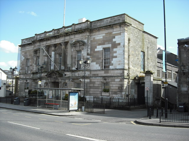


Baroque stonework fronts a steel-framed public hall.
Quick facts
- Date
- 1912
- Architect / designer
- John Thomson
- Type
- Town hall
- OS grid reference
- NS 75958 65368
The building and its setting
Cream sandstone, columns, balconies and carved heraldry give the street front an elaborate ceremonial character. Inside, HES describes a marble-lined lobby and a decorated, galleried auditorium.
Its story
John Thomson won the design competition, with Sir John Wilson contributing £10,000 towards construction. The hall was completed in 1912, the year the architect died. A council report of a school-band event in March 2026 confirms its continuing use for live performance.
Why it is included
This building represents the town’s investment in public assembly and performance.
What to look for
- The carved coat of arms and columned upper storey
- The relationship between ornate frontage and large hall behind
Reading the surroundings
Observe from public space; check current arrangements before entering buildings or grounds.
What we know — and what remains uncertain
The listing describes historic interiors; it is not a fresh condition survey. Current event access should be checked with the venue.
Sources & further reading
- Historic Environment Scotland: LB20947 — Designation, location, architectural description and historical information; not a current condition survey.
- North Lanarkshire Council: March 2026 concert report — Evidence of continuing performance use.
Location
OS grid reference NS 75958 65368 · Location confidence: HES catalogue grid converted to WGS84; approximate record location, not an entrance or boundary. · Select the marker to open its satellite view in Google Maps. On desktop, drag Pegman (the yellow figure) onto a blue road. On mobile, turn on the Street View layer and tap a blue road. Other photo markers may be user-contributed.
Suggest a marker correction
Suggest a more accurate position
The teal marker is the current published position. The orange marker starts slightly to its right so both remain visible; this is only a visual starting position. Tap the correct place on the map or drag the orange marker. Sending this form creates a private review entry only; it does not move the published marker.
Check this area in Google Maps Choose the Satellite layer there if useful.
Map: © OpenStreetMap contributors. You can also enter checked coordinates below.