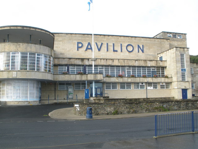
Image: Rothesay Pavilion by John Ferguson, sourced from Wikimedia Commons and licensed under CC BY-SA 2.0.

A sweeping glazed bow and sea-facing terraces made this inter-war pavilion a confident modern landmark for Clyde-coast entertainment.
Quick facts
- Date
- Competition won in 1936; building dated 1938
- Architect / designer
- James Andrew Carrick
- Type
- International Style entertainment pavilion with glazed bow, terraces and ancillary house
- Designation
- Listed building, Category A (LB40452)
- OS grid reference
- NS 08372 65068
Architecture and continuing use
The two-storey and basement pavilion uses a fully glazed curved wing, recessed vestibule, cantilevered terraces and flat roofs. Light-coloured artificial stone and long horizontal lines contrast with a cubic stair tower.
Its story
James Carrick won the design competition in 1936 and the pavilion opened in the late 1930s. It became a major island venue; a long-running conservation project is now intended to return it to cultural and community use.
Why it is included
It is a nationally important inter-war leisure building and an unusually ambitious expression of International Modernism in a Scottish resort.
What to notice
- The fully glazed bow facing the bay.
- Cantilevered terrace and strong horizontal bands.
- The contrast between curved public spaces and cubic stair tower.
Reading the surroundings
The building is a construction site and is not open. Observe barriers and project notices and consult the council’s page for current progress.
Timeline
- Competition won in 1936 James Carrick won the design competition in 1936 and the pavilion opened in the late 1930s. It became a major island venue; a long-running conservation project is now intended to return it to cultural and community use.
- Present Closed for a major council-led restoration and redevelopment.
What we know — and what remains uncertain
The council anticipates construction completion in early 2027, but project programmes can change and no reopening date is assumed here.
Sources & further reading
- Historic Environment Scotland: Rothesay Pavilion, LB40452 — Designation status, mapped location, construction phases, fabric, authorship and architectural or historical interest.
- Argyll and Bute Council: Rothesay Pavilion — Current project status, scope, ownership and programme.
Location
OS grid reference NS 08372 65068 · Location confidence: High: the statutory designation supplies an official mapped National Grid Reference and the current source confirms the Place relationship or present identity. · Select the marker to open its satellite view in Google Maps. On desktop, drag Pegman (the yellow figure) onto a blue road. On mobile, turn on the Street View layer and tap a blue road. Other photo markers may be user-contributed.
Suggest a marker correction
Suggest a more accurate position
The teal marker is the current published position. The orange marker starts slightly to its right so both remain visible; this is only a visual starting position. Tap the correct place on the map or drag the orange marker. Sending this form creates a private review entry only; it does not move the published marker.
Check this area in Google Maps Choose the Satellite layer there if useful.
Map: © OpenStreetMap contributors. You can also enter checked coordinates below.