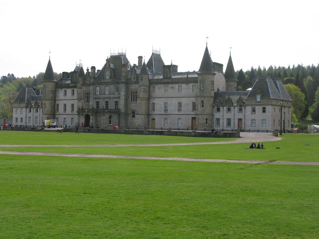
Image: Callendar House by G Laird, 4 May 2017, sourced from Wikimedia Commons / Geograph and licensed under CC BY-SA 2.0.
.jpg)
Callendar House is a 300-foot-long mansion whose French Renaissance exterior gathers a late medieval tower house, seventeenth-century extensions and Victorian remodelling into one of Falkirk’s most prominent public buildings.
Quick facts
- Date
- Late medieval origins; enlarged through the seventeenth century; remodelled 1869–77
- Architect / designer
- Brown and Wardrop, completed as Wardrop and Reid, over earlier work including alterations by David Hamilton
- Type
- Country house with medieval core and French Renaissance remodelling
- Designation
- Listed building, Category A (LB31236)
- OS grid reference
- NS 89864 79352
An old house inside a Victorian composition
The north-west corner contains a small tower house, probably of the late fourteenth century. An eastward wing created an L-plan; seventeenth-century extensions then lengthened the main range and low two-storey wings brought the frontage to roughly 300 feet. This long chronology survives beneath an exterior that reads at first as a single nineteenth-century design.
Brown and Wardrop began the major remodelling of 1869–77, completed as Wardrop and Reid. Harled surfaces and many earlier openings were retained but enriched with French Renaissance detail: projecting bay windows rise into steep roofs, tourelles mark corners, rebuilt chimneys carry diamond panels and a high pavilion roof crowns the stair-hall block. The south front has a double staircase and first-floor balcony; the north front is approached through a lower entrance hall and porch.
Interiors and changing ownership
Inside, the building records several campaigns. Historic Environment Scotland notes a Baroque painted ceiling, a neo-Greek pilastered and barrel-vaulted library and a small drawing room associated with David Hamilton’s alterations of 1827. Other rooms were modified during the Victorian remodelling, and an older staircase was substantially renewed after fire damage.
The Livingston family held Callendar for almost four centuries after receiving the lands in the mid-fourteenth century. The estate was forfeited after the Jacobite rising of 1715 and later acquired by the Forbes family, whose improvements included work by David Hamilton and whose influence extended into Falkirk’s nineteenth-century development. The estate passed to Falkirk Burgh Council in 1963. After years of dereliction, the house was restored by the present council and reopened for public use in 1997.
Why it matters
The house is the architectural centre of an extensive listed estate group and the most prominent historic building in Callendar Park. Its importance comes from the exceptional survival of successive domestic campaigns, the ambitious 1869–77 transformation and its long association with families who shaped the estate and town. Museum use now turns that layered fabric into a public resource rather than a private mansion.
What to notice
- The extraordinary length of the frontage and the way low wings balance the older central ranges.
- Steep French roofs, tourelles, bay windows and patterned chimneys added in 1869–77.
- The contrast between the formal south approach and the north entrance front.
- The oak-panelled Victorian library, now used by Falkirk Archives.
- The relationship between the house, terraces, mature parkland and the wider Callendar estate group.
Visiting and access
Callendar House is a Falkirk Council museum and gallery with free entry. The current venue information lists opening from 10:00 to 17:00 Wednesday to Monday, with Tuesday closure and last admission at 16:30. The house includes museum displays, changing exhibitions, a tearoom, gift shop and Falkirk Archives; archive consultation and special rooms may have separate arrangements or require advance contact. The council describes the building as wheelchair accessible and provides disabled parking near the house, but temporary lift or room closures can occur, so check the official venue page before travelling.
Callendar Park is a public historic landscape of more than 170 acres and includes a section of the Antonine Wall World Heritage Site. Park opening, parking and events are managed separately from the museum, and private functions can temporarily affect access to individual rooms.
Timeline
- Mid-fourteenth century The lands of Callendar were granted to the Livingston family.
- Late fourteenth century The earliest surviving tower-house core was probably built.
- Seventeenth century Successive extensions created a long symmetrical house with terminal wings.
- 1715 and after The estate was forfeited following the Jacobite rising and later changed hands.
- Late eighteenth century William Forbes acquired the estate; James Craig proposed internal alterations in 1785, though the extent executed is uncertain.
- 1827 David Hamilton altered interiors, including the small drawing room.
- 1869–77 Brown and Wardrop, completed as Wardrop and Reid, recast the exterior in a French Renaissance manner.
- 1963 The Forbes family sold the estate to Falkirk Burgh Council.
- 1997 Following restoration, the house reopened in public cultural use.
- Present Callendar House serves as museum, gallery, archive, tearoom and civic venue.
What remains uncertain
The statutory record describes the earliest tower as probably late fourteenth-century and notes that James Craig’s proposed 1785 alterations may not have been carried out. Those qualifications matter: the building is well documented, but not every early phase can be dated or attributed with equal certainty.
Sources & further reading
- Historic Environment Scotland: Callendar House, LB31236 — Category A designation, construction sequence, architecture, interiors, ownership and restoration history.
- Falkirk Council: Callendar House — Current museum, gallery, archive, tearoom, access and opening information.
- Falkirk Council: arts and culture venue — Current public ownership and setting within Callendar Park and the Antonine Wall landscape.
Location
OS grid reference NS 89864 79352 · Location confidence: High: the statutory designation supplies an official mapped National Grid Reference and the current source confirms the Place relationship or present identity. · Select the marker to open its satellite view in Google Maps. On desktop, drag Pegman (the yellow figure) onto a blue road. On mobile, turn on the Street View layer and tap a blue road. Other photo markers may be user-contributed.
Suggest a marker correction
Suggest a more accurate position
The teal marker is the current published position. The orange marker starts slightly to its right so both remain visible; this is only a visual starting position. Tap the correct place on the map or drag the orange marker. Sending this form creates a private review entry only; it does not move the published marker.
Check this area in Google Maps Choose the Satellite layer there if useful.
Map: © OpenStreetMap contributors. You can also enter checked coordinates below.