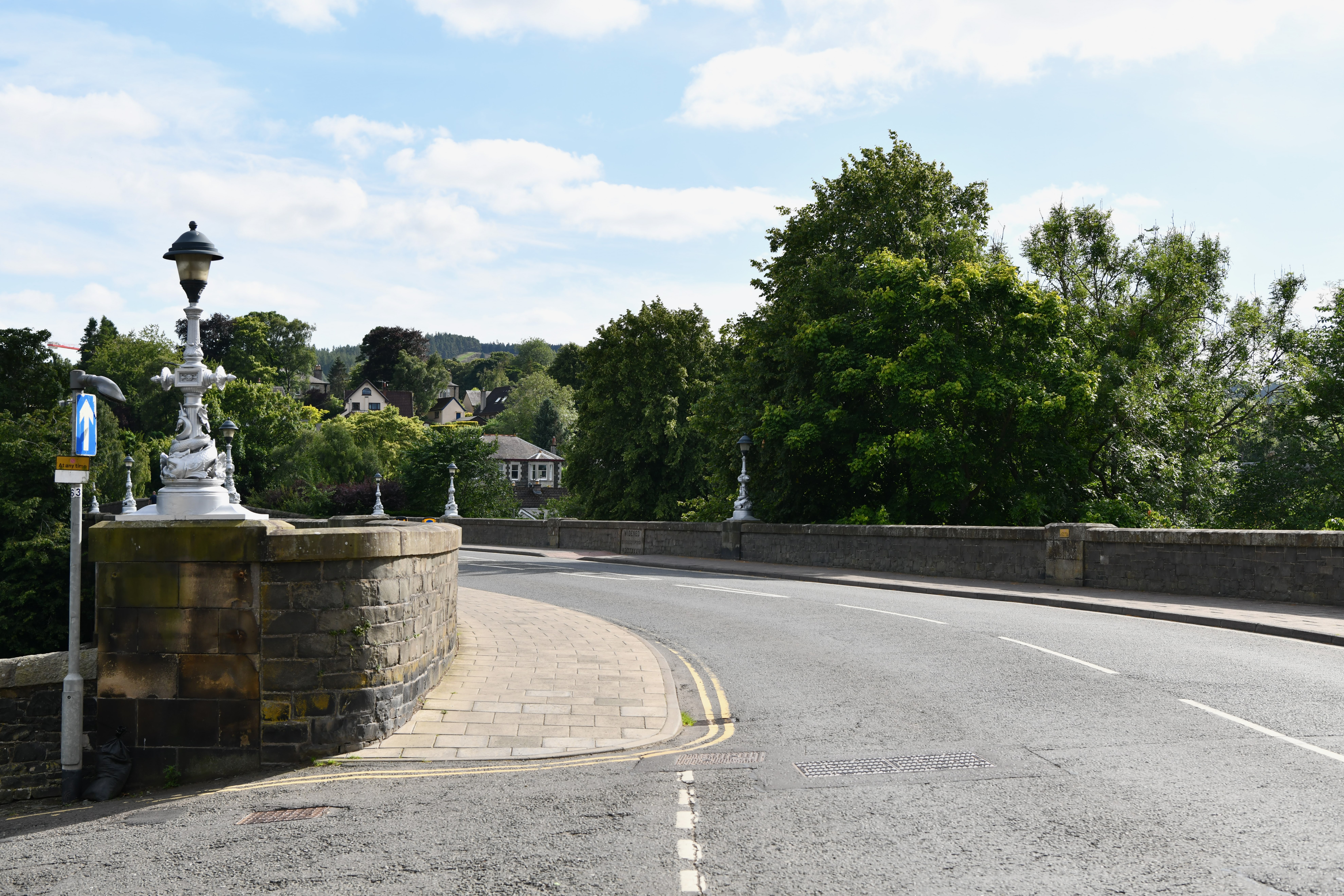
Image: Tweed Bridge by Michael Garlick, 14 August 2024, sourced from Wikimedia Commons and licensed under CC BY-SA 2.0.

Tweed Bridge is Peebles’ historic gateway across the river: a medieval crossing repeatedly widened to carry modern traffic while preserving five substantial stone arches and traces of its earlier fabric. Its layered masonry, right-angled approach ramp and dolphin-decorated lamps make the town’s everyday road bridge an unusually readable record of adaptation.
Quick facts
- Date
- Probably medieval; widened in 1834 and 1897–1900
- Designers
- Medieval builders; John and Thomas Smith; McTaggart, Cowan and Barker
- Type
- Five-span masonry road bridge with later widening and approach ramp
- Designation
- Listed building, Category A (LB39278)
- OS grid reference
- NT 25043 40305
- Current use
- Active public road and pedestrian crossing
A bridge made by enlargement
The principal river crossing has five segmental arches, each about 40 feet wide, with the bridge slightly splayed at its ends. At the north-east a five-arched, round-headed ramp turns at a right angle towards Tweed Green. To the south, the group meets a railway bridge carried on Glengarnock steel beams. This is not one uniform campaign but a composite structure whose changing functions remain visible.
Whinstone faces the bridge, with cream sandstone used for dressings. On the upstream side, ashlar cutwaters merge into bull-faced extensions belonging to the later widening. Earlier archwork can still be detected beneath and beside the additions. Piers rise between the arches, and a dentil course supports the parapet.
Medieval origins
Historic Environment Scotland considers the oldest portion probably mid-fifteenth-century, while allowing that it may be earlier. Much of that fabric is now obscured by repair and widening. The designation cautiously suggests that John of Peebles, the master mason associated with work on Perth’s Tay Bridge in the fifteenth century, may also have been involved here; this remains an attribution rather than a documented certainty.
The crossing was repaired repeatedly in the seventeenth and eighteenth centuries. That long continuity matters: instead of abandoning the medieval route, successive generations strengthened and enlarged it, preserving the bridge’s position at the meeting point of the High Street, Old Town and roads south of the Tweed.
The 1834 widening
By the nineteenth century the old roadway was only about eight feet wide. John and Thomas Smith of Darnick widened it on both sides in 1834, increasing the width to roughly 21 feet. The work was funded by public subscription and is commemorated by ashlar plaques on the inner and outer faces of the west parapet.
The widening did not erase the older bridge. Instead, new masonry was built alongside it, creating the construction seams and differing arch profiles that reward a careful view from the riverbanks.
The municipal bridge of 1897–1900
Traffic pressure led Peebles Town Council to double the width again on the downstream, or eastern, side between 1897 and 1900. McTaggart, Cowan and Barker directed the scheme. The bridge reached about 40 feet in overall width, allowing it to continue as the town’s main vehicular crossing.
Cast-iron lamps stand on the parapet piers. Their entwined dolphins are a surprisingly elaborate civic detail: ornamental metalwork marks a practical improvement and gives the bridge a recognisable silhouette after dark.
Current role and access
Tweed Bridge remains an active public road and pedestrian crossing. Scottish Borders Council’s transport-planning page treats it as the existing vehicular bridge whose capacity was examined in the Peebles traffic study. The Council’s 2025 walking booklet also uses the south side of Tweed Bridge as the starting point for the Sware Circuit and directs walkers across the bridge towards the riverside path.
This is not a traffic-free monument. Visitors should use the pavements and designated crossings, remain alert to vehicles, and avoid stopping in the carriageway to inspect masonry. Better views of the arches and different widening phases are available from lawful riverside paths, subject to weather, river levels and local signs.
Why it matters
The bridge combines rare continuity with everyday usefulness. Medieval masonry, nineteenth-century engineering, municipal ornament and twentieth- and twenty-first-century traffic all occupy the same crossing. Its Category A designation recognises not only age but the survival of distinct construction phases and the bridge’s central place in the form and movement of Peebles.
What to notice
- The five principal segmental arches and their slightly splayed alignment.
- Earlier archwork and construction seams visible beneath later widening.
- Upstream ashlar cutwaters merging into rougher bull-faced eastern extensions.
- The 1834 commemorative plaques on the west parapet.
- The right-angled five-arch ramp towards Tweed Green.
- Cast-iron lamps decorated with intertwined dolphins.
- The junction with the southern railway bridge and its steel beams.
Timeline
- Probably mid-fifteenth century The oldest surviving stone crossing is established or substantially rebuilt.
- Seventeenth and eighteenth centuries Repeated repairs keep the bridge in service.
- 1834 John and Thomas Smith widen the roadway from about eight to 21 feet by public subscription.
- 1897–1900 Peebles Town Council doubles the width to the east under McTaggart, Cowan and Barker.
- 1971 The bridge is designated Category A.
- 2012 onward Council transport studies examine capacity and possible additional crossings while Tweed Bridge remains the established town-centre route.
- 2026 The bridge continues to carry road traffic and pedestrians across the Tweed.
What remains uncertain
The exact date of the medieval work is not established, and John of Peebles’ involvement is a reasoned possibility rather than a securely documented commission. The designation states that the bridge was de-scheduled in 1996; this removed a former scheduled-monument status but did not remove the Category A listed-building designation, which remains current.
Sources & further reading
- Historic Environment Scotland: Tweed Bridge, LB39278 — Designation, mapped location, medieval fabric, widening campaigns, materials, designers and statement of special interest.
- Scottish Borders Council: transport plans and Peebles bridge study — Current role of Tweed Bridge in the town’s road network and the Council’s capacity study.
- Scottish Borders Council: Paths Around Peebles — 2025 walking routes using the bridge and adjoining riverside paths.
Location
OS grid reference NT 25043 40305 · Location confidence: High: the statutory designation supplies an official mapped National Grid Reference and the current source confirms the Place relationship or present identity. · Select the marker to open its satellite view in Google Maps. On desktop, drag Pegman (the yellow figure) onto a blue road. On mobile, turn on the Street View layer and tap a blue road. Other photo markers may be user-contributed.
Suggest a marker correction
Suggest a more accurate position
The teal marker is the current published position. The orange marker starts slightly to its right so both remain visible; this is only a visual starting position. Tap the correct place on the map or drag the orange marker. Sending this form creates a private review entry only; it does not move the published marker.
Check this area in Google Maps Choose the Satellite layer there if useful.
Map: © OpenStreetMap contributors. You can also enter checked coordinates below.