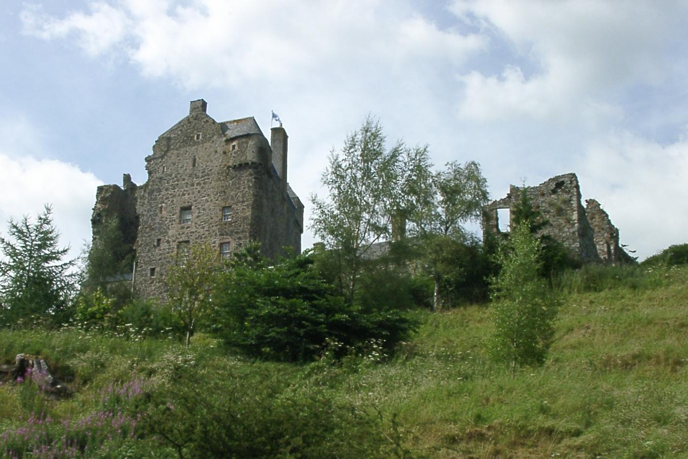
Image: Neidpath Castle by Vclaw, 22 July 2005, sourced from Wikimedia Commons and licensed under CC BY-SA 2.0.

Neidpath Castle is a remarkably intact medieval tower house set on a steep bend of the River Tweed west of Peebles. Its oblique plan, mural rooms, iron yetts and covered wall walks preserve the logic of a defended residence, while the courtyard, gateway, yew avenue and former garden show how the Hays of Yester reshaped the site for seventeenth-century status and comfort.
Quick facts
- Date
- Medieval; substantially remodelled in the mid-seventeenth century
- Architect / designer
- Unknown medieval builders; later work for the Hays of Yester
- Type
- Fortified tower house with courtyard ranges, gateway, former walled garden and boundary walls
- Designation
- Listed building, Category A (LB13857)
- OS grid reference
- NT 23618 40487
- Access
- Private property; advertised tour dates and private tours by appointment
A castle shaped by its site
The castle stands above the Tweed on ground so steep and irregular that its main block is not a tidy rectangle. Historic Environment Scotland describes an L-plan tower whose walls meet at oblique angles, probably in response to the rock beneath it. Rounded outer corners and high parapets give the building a powerful, almost continuous silhouette without the projecting bartizans common on many Scottish tower houses.
The east, or principal, elevation now has a bolection-moulded entrance reached by radial steps. This doorway was formed from an earlier window; the medieval entrance survives on the precipitous south side. Covered walks run behind parts of the corbelled parapet. Small windows, arrow slits and pistol loops contrast with larger seventeenth-century openings inserted when the castle was made more comfortable.
Rooms within the walls
Neidpath’s thick masonry contains much of the accommodation. A stone-flagged entrance lobby leads towards the principal turnpike stair, with a vaulted cell opposite that may have served as a porter’s lodge. Other features recorded by the designation include a barrel-vaulted chamber, mural garderobes, aumbrys, a service stair and a prison pit with a latrine reached through an upper hatch.
A central vault divided the tower vertically, with the great hall placed above it. Later work introduced an entresol on timber joists and a scale-and-platt stair with solid newel and bottle-nosed treads. In the west wing, an earlier roll-moulded fireplace carries a fleur-de-lis on its lintel. These layers make the interior especially valuable: medieval circulation and defence remain legible beside the alterations of a later aristocratic household.
From Fraser stronghold to Hay residence
The castle’s own history identifies the Frasers as the first lords of Neidpath and associates Sir Gilbert Fraser with an early stronghold around 1190. It presents the existing tower as largely late medieval, probably built for the Hays after Mary Fraser’s marriage to Sir Gilbert Hay in 1312. That early chronology is not securely resolved by the visible fabric, so it is safer to treat the twelfth-century date as the estate’s historical account rather than a precise date for the standing walls.
Neidpath remained with the Hays of Yester for centuries. The operator records visits by Mary, Queen of Scots in 1563 and James VI in 1587. Historic Environment Scotland dates a major enlargement to 1654, while the castle’s account describes remodelling and new outbuildings in the 1660s after damage during Cromwell’s invasion. Together, the sources point to a sustained mid-seventeenth-century campaign rather than a single building event.
The Hays sold Neidpath to William Douglas, first Duke of Queensberry, in 1686. The castle later passed to the Wemyss family through the inheritance of Francis Charteris, sixth Earl of Wemyss, in 1810. By then parts of the west wing had already fallen, but the surviving tower, later additions and principal rooms continued to be maintained.
Courtyard, gateway and landscape
The Category A designation extends beyond the tower. South and east courtyard ranges include a keeper’s cottage, earlier service fabric and a building interpreted as a sixteenth-century brew- or bakehouse. The entrance gateway, dated to about 1672, has a semicircular arch, hood-mould, carved stops, alternating ornamented and rusticated voussoirs, and the arms of the Earls of Tweeddale.
North of the drive, walls define the former garden and nursery. A surviving line of yews belongs to an avenue associated with the mid-seventeenth-century remodelling. Historic Environment Scotland also notes the remains of terraced gardens east of the castle and the importance of views from across the river, including Artist’s Rock, a favoured viewpoint for landscape painters.
Siege, damage and repair
The designation records the tradition that Cromwell’s cannon stood in the nearby Deer Park during a siege, damaging the west wing. The castle’s history places the episode during the invasion of 1650. The exact sequence of destruction and rebuilding is not completely documented, but the contrast between the intact main tower and the partly ruinous wing makes the disruption visible.
A protective grey-slated roof was installed around 1938. Its open timber construction helped secure the upper structure while leaving the massive masonry and wall walks legible. The work forms part of the long history of adaptation that has kept the building usable without disguising its medieval character.
Why Neidpath matters
Neidpath is important not simply because it is old, but because an unusually broad group survives together: fortified tower, internal stairs and chambers, courtyard buildings, armorial gateway, garden walls, yews and river setting. The building shows how a Scottish tower house could be enlarged for seventeenth-century life while retaining its defensive form. Its Category A designation recognises both the architectural fabric and the way the parts combine into a coherent historic estate.
Visiting and access
Neidpath is private property and should not be treated as an attraction with daily walk-in opening. The castle advertises individual public tour dates; at the time of review, the remaining 2026 dates were Thursday 15 October at 2pm and Thursday 12 November at 7pm. Tickets must be booked through the castle. Private tours are available throughout the year by appointment, and the building is also used for weddings, events and arranged stays.
The castle is about a mile west of Peebles. Historic steps, uneven floors, narrow stairs and steep ground are inherent in the site; visitors with access requirements should discuss the route with the operator before booking. Estate accommodation or an event booking does not imply unrestricted access to the whole castle or its grounds. Exterior views from lawful public routes must likewise respect signs, gates and private land.
What to notice
- The oblique L-plan and rounded corners, shaped by the steep riverside rock.
- The contrast between narrow defensive openings and larger seventeenth-century windows.
- Iron yetts surviving at the former entrance and reused as window bars.
- The covered parapet walks, mural chambers and stairs contained within the thickness of the walls.
- The armorial gateway and the relationship between tower, courtyard ranges and yew avenue.
- The partly ruined west wing, which makes the castle’s episodes of damage and repair visible.
Timeline
- Medieval period A fortified residence develops above the Tweed; the precise date of the earliest standing work remains uncertain.
- 1312 The barony passes to the Hay family through the marriage of Mary Fraser and Sir Gilbert Hay, according to the castle’s history.
- 1563 and 1587 The operator records visits by Mary, Queen of Scots and James VI.
- 1650s–1660s After damage associated with Cromwell’s invasion, the Hays enlarge and remodel the castle, courtyard and landscape.
- 1686 The estate is sold to William Douglas, first Duke of Queensberry.
- 1810 Neidpath passes to Francis Charteris, sixth Earl of Wemyss.
- Circa 1938 A protective slated roof helps secure the upper structure.
- 2026 The privately managed castle offers limited advertised tours and private visits by appointment.
What remains uncertain
The date and authorship of the earliest surviving masonry are not established. The castle’s history gives a traditional early foundation and a probable late-fourteenth-century date for the present tower, while the designation is more cautious and describes the building broadly as medieval. Accounts also vary in whether the principal later campaign is expressed as 1654 or the 1660s. These differences are best understood as overlapping phases of damage, enlargement and estate improvement rather than forced into a single exact date.
Sources & further reading
- Historic Environment Scotland: Neidpath Castle, LB13857 — Designation, mapped location, architectural description, associated structures and statement of special interest.
- Neidpath Castle: history — Estate account of ownership, royal visits, later inheritance and the survival of the castle.
- Neidpath Castle: contact and tours — Current 2026 public tour dates, private-tour arrangements and travel information.
- Neidpath Castle: events — Current event use and booking arrangements.
Location
OS grid reference NT 23618 40487 · Location confidence: High: the statutory designation supplies an official mapped National Grid Reference and the current source confirms the Place relationship or present identity. · Select the marker to open its satellite view in Google Maps. On desktop, drag Pegman (the yellow figure) onto a blue road. On mobile, turn on the Street View layer and tap a blue road. Other photo markers may be user-contributed.
Suggest a marker correction
Suggest a more accurate position
The teal marker is the current published position. The orange marker starts slightly to its right so both remain visible; this is only a visual starting position. Tap the correct place on the map or drag the orange marker. Sending this form creates a private review entry only; it does not move the published marker.
Check this area in Google Maps Choose the Satellite layer there if useful.
Map: © OpenStreetMap contributors. You can also enter checked coordinates below.