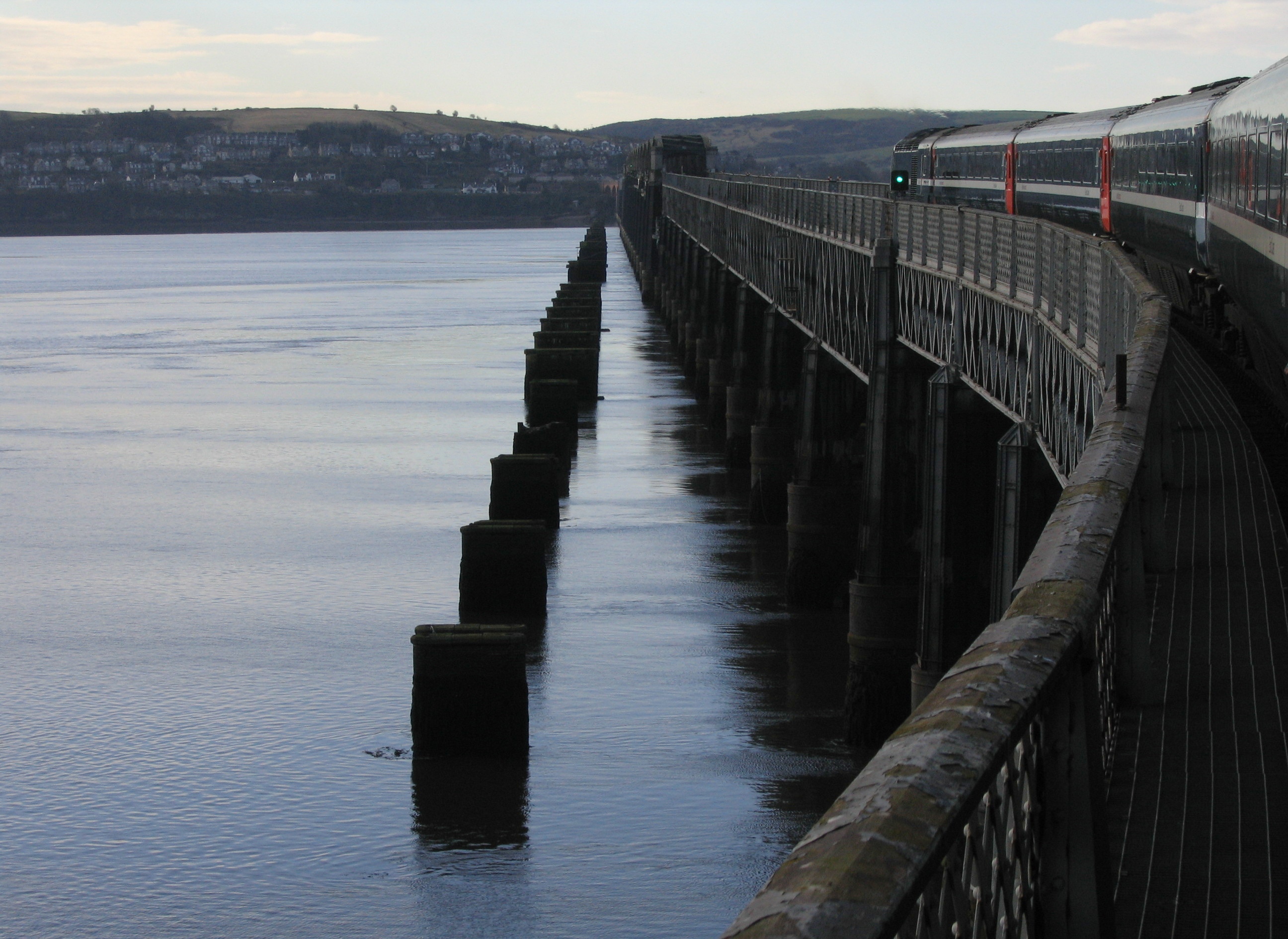
Image: Tay Railway Bridge seen alongside a passing train, with the piers of the earlier bridge standing in the estuary by Klaus with K, licensed under CC BY-SA 4.0.

The second Tay Railway Bridge is a vast working monument to Victorian railway engineering, built after the 1879 disaster and still carrying trains across more than three kilometres of tidal estuary between Dundee and Fife.
Quick facts
- Date
- Built 1882–1887, incorporating surviving girders from the first bridge of 1871–1877
- Engineer / contractor
- William Henry Barlow and Crawford Barlow; William Arrol and Company
- Type
- Double-track wrought-iron railway bridge and approach viaducts
- Designation
- Listed structure, Category A (LB25681)
- OS grid reference
- NO 39143 27850 (catalogue midpoint only)
A railway across the Tay
The bridge runs between Dundee and Wormit, crossing one of Scotland’s broadest tidal landscapes. Historic Environment Scotland gives the listed length as 10,711 feet, or 3.264 kilometres, and includes the brick approaches at both ends, the wrought-iron river crossing and the downstream piers left from the first bridge. It is therefore best understood as an extended engineering system rather than a single repeated span.
From the south, four brick arches at Wormit widen to serve the divergence of routes towards Newport and Edinburgh. The south approach then advances across piers formed from paired wrought-iron cylinders, lined with brick and filled with concrete below water level. Above them, octagonal plate-iron shafts, iron connections and long lattice girders create the measured rhythm seen from the shore.
Navigation spans and Dundee approach
Thirteen central navigation spans cross the shipping channel. Their parabolic, hog-backed girders rise above track level and provide the bridge’s most dramatic silhouette. Historic Environment Scotland records clearances of 77 feet for shipping, with dated plaques at the entrances to the navigation section. Cast-iron arches and piers support the wrought-iron superstructure.
North of the channel, the line falls and then curves towards Dundee station. The spans become narrower and the supports change to trabeated cast-iron piers filled with brick and concrete. Near the Esplanade, skew arches carry the railway over Riverside Drive before the structure meets the station approaches, offices and workshops. These changes in gradient, curvature, span and material are responses to navigation, geology and the existing city rather than decorative variation.
The first bridge and the 1879 disaster
The first Tay Bridge was designed by Thomas Bouch for the North British Railway and opened on 31 May 1878 after a difficult construction campaign. Network Rail records that passenger traffic between Dundee and Fife doubled and freight increased by 40 per cent within a year, showing the crossing’s immediate economic effect.
On 28 December 1879, during a severe storm, the thirteen central high girders collapsed while a train was crossing. The Court of Inquiry blamed the bridge’s design and placed responsibility on Bouch. The disaster changed the course of British bridge engineering: a replacement could not simply repeat the earlier structure or treat wind loading as a secondary matter.
Barlow and Arrol’s replacement
William Henry Barlow, who had served on the inquiry, recommended an entirely new double-track bridge. Parliament accepted the replacement proposals in October 1881, and William Arrol and Company of Glasgow became contractor. The new line was set about 60 feet upstream, while the remains of the old bridge served as staging during construction.
The design retained useful material without pretending that the first bridge could be restored wholesale. On parts of the approaches, Barlow’s new wrought-iron girders were placed between sound girders recovered from Bouch’s bridge. The navigation spans were entirely new. Arrol devised pontoon equipment with hydraulic legs to build foundation cylinders, erect piers, move reused girders and assemble the high spans. Weight and wind tests were deliberately stringent.
The replacement took five years to build and opened without ceremony on 20 June 1887. Its double track, lower navigation height and altered approaches answered both operational needs and lessons drawn from the catastrophe.
Survival, memory and continuing use
The present bridge remains an operational part of the railway between Dundee and Fife. Its continuing function distinguishes it from an abandoned industrial monument, but it also means that the structure is not a pedestrian attraction. The parallel downstream piers of the first bridge make the disaster physically legible in the landscape and should be interpreted as archaeological evidence, not as an invitation to approach across tidal ground.
Historic Environment Scotland describes the crossing as the longest bridge in Britain and perhaps the largest wrought-iron structure in the world. Those words come from the designation’s statement of special interest and reflect the extraordinary scale of the surviving fabric.
Why it matters
The Category A listing recognises more than length. The bridge combines large-scale wrought-iron construction, pioneering foundation and erection methods, carefully differentiated approaches and navigation spans, and the material evidence of a predecessor whose failure transformed engineering practice. It also remains central to the east-coast railway and to Dundee’s relationship with Fife.
What to notice
- The change from straight southern spans to the curve approaching Dundee station.
- The thirteen high, hog-backed navigation girders rising above rail level.
- The repeated cylindrical and octagonal piers across the tidal water.
- Brick approach arches contrasting with the iron river crossing.
- The downstream line of first-bridge piers, read only from safe public viewpoints.
- The way the bridge’s length compresses or expands visually with distance and weather.
Viewing and access
The bridge carries an operational railway and has no public pedestrian route. Railway land, maintenance areas, piers and track must not be entered. The structure can be appreciated from lawful public waterfront viewpoints in Dundee and on the Fife shore; remain behind barriers, avoid tidal mud and follow local waterside and railway safety instructions. Train passengers experience the crossing in operation, but windows and movement limit close architectural observation.
The catalogue marker is deliberately only a midpoint reference. A point cannot represent a structure more than three kilometres long, and no unverified line geometry has been published on this record.
Timeline
- 1871–1877 Thomas Bouch’s first Tay Bridge was constructed.
- 31 May 1878 The first bridge opened to railway traffic.
- 28 December 1879 The central high girders collapsed in a storm while a train was crossing.
- October 1881 Parliament accepted proposals for a new double-track bridge.
- 1882–1887 William Arrol and Company constructed Barlow’s replacement, reusing sound girders on parts of the approaches.
- 20 June 1887 The present bridge opened to traffic without ceremony.
- Present The bridge remains in operational railway use between Dundee and Fife.
What we know — and what remains uncertain
Historic Environment Scotland gives the listed length as 10,711 feet (3.264 kilometres), while Network Rail also describes the crossing as 2 miles 73 yards (3,286 metres). The difference may reflect measurement conventions and the limits chosen for the approaches; both figures are retained rather than forced into false agreement. The designation precisely distinguishes Bouch girders reused on parts of the approaches from Arrol’s new navigation spans. This record does not publish a route line until a reviewed, rights-clear geometry can represent the full listed structure accurately.
Sources & further reading
- Historic Environment Scotland: Tay Railway Bridge, LB25681 — Category A designation, full listed extent, structural sequence, materials, designers, contractors and statement of special interest.
- Network Rail: the history of the Tay Bridge — First-bridge traffic effects and failure, inquiry, replacement design, construction methods, testing, dimensions and opening date.
Location
OS grid reference NO 39143 27850 (catalogue midpoint only) · Location confidence: High for a representative point: HES catalogue midpoint NO 39143 27850 identifies the full bridge. This point is not an entrance or pedestrian access point; no surveyed line geometry is supplied. Approved 28 September 2026. · Select the marker to open its satellite view in Google Maps. On desktop, drag Pegman (the yellow figure) onto a blue road. On mobile, turn on the Street View layer and tap a blue road. Other photo markers may be user-contributed.
Suggest a marker correction
Suggest a more accurate position
The teal marker is the current published position. The orange marker starts slightly to its right so both remain visible; this is only a visual starting position. Tap the correct place on the map or drag the orange marker. Sending this form creates a private review entry only; it does not move the published marker.
Check this area in Google Maps Choose the Satellite layer there if useful.
Map: © OpenStreetMap contributors. You can also enter checked coordinates below.