In brief
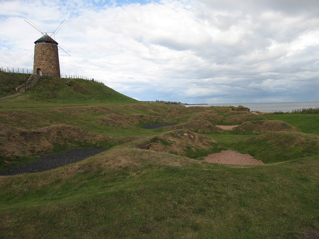
On the East Braes, a circular windmill tower stands among the low remains of nine saltpan houses. The works used wind power to lift seawater and coal to heat the pans. Together, tower, panhouses, channels and buried archaeology preserve a rare industrial landscape rather than a picturesque windmill in isolation.


Quick facts
- National designation
- Scheduled monument, SM5529
- Grid reference
- NO 53369 01753
- Working period
- 1770s to the 1820s
- Designation note
- Specified modern stairs, platform, roof, windows, sails and other fittings are excluded from the scheduling
Wind, coal and seawater
The Newark Coal and Salt Company developed the works between 1772 and 1774. A wind engine raised seawater to feed the pans, where coal-fired evaporation produced salt. HES records the tower, nine panhouses, a former wagonway and associated archaeology within the scheduled area.
Survival and reconstruction
The tower is about nine metres high and was reconstructed in 1992. That date is essential context: the visible sails and upper fittings should not be read as untouched eighteenth-century fabric. The scheduling protects the archaeological and structural evidence while explicitly excluding several modern access and reconstructed elements.
Sources
- Historic Environment Scotland — SM5529 — Current scheduled-monument record for the windmill, saltpans and associated archaeology.
- Fife Council — St Monans Conservation Area Appraisal and Management Plan — Landscape setting, geology, settlement growth, harbour phases, fishing, boatbuilding, saltmaking and townscape character.
Explore the Place
Read the wider landscape and settlement story on the St Monans Place page.
Location
OS grid reference NO 53369 01753 · Location confidence: High — coordinates derived from the current HES designation map reference · Select the marker to open its satellite view in Google Maps. On desktop, drag Pegman (the yellow figure) onto a blue road. On mobile, turn on the Street View layer and tap a blue road. Other photo markers may be user-contributed.
Suggest a marker correction
Suggest a more accurate position
The teal marker is the current published position. The orange marker starts slightly to its right so both remain visible; this is only a visual starting position. Tap the correct place on the map or drag the orange marker. Sending this form creates a private review entry only; it does not move the published marker.
Check this area in Google Maps Choose the Satellite layer there if useful.
Map: © OpenStreetMap contributors. You can also enter checked coordinates below.