In brief
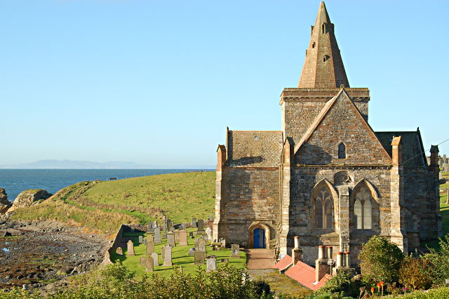
St Monan’s Church stands low beside the Firth, apart from the compact harbour village. Its T-plan form, crossing tower and vaulted interior preserve later-medieval work, but the building also records major nineteenth- and twentieth-century campaigns. The churchyard wall, bridge and gatepiers are part of the listed ensemble.


Quick facts
- National designation
- Category A listed building, LB15558
- Grid reference
- NO 52265 01443
- Main phases
- Later fourteenth century; 1826–28; circa 1900; 1955–60
- Access note
- Designation does not imply public access; current arrangements are not reproduced
Medieval form and later hands
Historic Environment Scotland dates most of the fabric to the later fourteenth century and names Sir William Dishington as master of works. The crossing tower, faceted spire, traceried windows and stone vaulting give the church its exceptional silhouette and interior character. William Burn’s restoration of 1826–28 altered openings and renewed fabric; Peter MacGregor Chalmers added a vestry around 1900, and Ian G. Lindsay and Partners restored the church in 1955–60.
What survives
The building is not a pristine medieval survival. Consecration crosses, sedilia, aumbry, vault bosses and an eighteenth-century votive ship sit within a fabric repeatedly repaired and re-ordered. HES also includes the enclosed churchyard, its rubble wall, entrance bridge, ashlar gatepiers and cast-iron gates in the description.
Sources
- Historic Environment Scotland — LB15558 — Current Category A listing for St Monan’s Church and Churchyard.
- Fife Council — St Monans Conservation Area Appraisal and Management Plan — Landscape setting, geology, settlement growth, harbour phases, fishing, boatbuilding, saltmaking and townscape character.
Explore the Place
Read the wider landscape and settlement story on the St Monans Place page.
Location
OS grid reference NO 52265 01443 · Location confidence: High — coordinates derived from the current HES designation map reference · Select the marker to open its satellite view in Google Maps. On desktop, drag Pegman (the yellow figure) onto a blue road. On mobile, turn on the Street View layer and tap a blue road. Other photo markers may be user-contributed.
Suggest a marker correction
Suggest a more accurate position
The teal marker is the current published position. The orange marker starts slightly to its right so both remain visible; this is only a visual starting position. Tap the correct place on the map or drag the orange marker. Sending this form creates a private review entry only; it does not move the published marker.
Check this area in Google Maps Choose the Satellite layer there if useful.
Map: © OpenStreetMap contributors. You can also enter checked coordinates below.