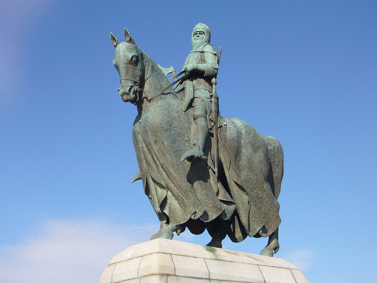
Image: Robert the Bruce Memorial at Bannockburn by Kim Traynor, sourced from Wikimedia Commons and licensed under CC BY-SA 3.0.

A carefully choreographed post-war landscape of architecture and sculpture, the Bannockburn rotunda, cairn, flagpole and equestrian Bruce turn the traditional Borestone site into a modern national memorial.
Quick facts
- Date
- Flagpole erected in 1870; cairn built in the 1950s; commemorative landscape, rotunda and statue completed for the 650th anniversary in 1964
- Architect / designer
- Overall concept by Sir Robert Matthew; landscape by H. F. Clark; rotunda project architect F. R. (Eric) Stevenson; statue by Charles d’Orville Pilkington Jackson
- Type
- Modern commemorative landscape with circular enclosure, memorial cairn, flagpole and equestrian bronze
- Designation
- Listed building, Category A (LB49860)
- OS grid reference
- NS 79488 90691
Architecture and landscape
The listed ensemble is not a single monument but a sequence. A tree-lined route draws visitors from the approach towards the Borestone, traditionally identified as the place where Robert I raised his standard before the battle. The stone fragments were gathered into a cairn beneath a tall flagpole. Around them, the 1960s designers placed an open circular rotunda of concrete-block panels, capped by a strong horizontal rail and entered beside large rough boulders.
The enclosure has two deliberate openings. One looks south towards the traditional line of Edward II’s advance; the other turns north towards Pilkington Jackson’s equestrian statue and, beyond it, Stirling Castle—the English army’s objective in 1314. The bronze king, shown in light armour with a battle-axe, sits high on a white-granite plinth. Architecture, planting, sculpture and long views therefore work together as one commemorative composition.
Designing a place of memory
The Borestone had already attracted commemoration before the post-war scheme: a flagpole was erected in 1870, and its surviving fragments were incorporated into a cairn in the 1950s. For the battle’s 650th anniversary, Sir Robert Matthew conceived a wider redefinition of the site. H. F. Clark devised the planted landscape, and Eric Stevenson acted as project architect for the buildings. The intended orientation building was not attached to the rotunda; the visitor facilities developed separately and are not part of this listing.
The rotunda’s simple geometry gives the site an almost ceremonial stillness. Historic Environment Scotland notes possible echoes of prehistoric henge monuments and of Gunnar Asplund’s Woodland Cemetery in Stockholm. Those comparisons are interpretive, but the design intention is clear: visitors move through a sequence of framed directions rather than encounter an isolated statue.
The equestrian Bruce
Charles d’Orville Pilkington Jackson’s statue was cast in bronze by H. H. Martyn & Co. of Cheltenham and unveiled on Bannockburn Day in 1964. Its commanding scale and southward orientation make Robert I appear to confront the line of advance and protect the route towards Stirling Castle. The composition has become one of Scotland’s best-known post-war public sculptures.
The portrait should not be mistaken for a direct medieval likeness. Jackson used evidence associated with the skull rediscovered at Dunfermline Abbey, but the result remains a twentieth-century act of historical reconstruction and national commemoration.
Battlefield and memorial
The Battle of Bannockburn was fought over two days, 23–24 June 1314, across a much larger and still-debated landscape. Robert I’s victory over Edward II strengthened his effective control of Scotland, although the Wars of Independence continued. This listed group marks a traditional focus of memory within that wider battlefield; it does not define the full area of fighting or prove that every commemorated event occurred at this exact point.
That distinction is part of the site’s significance. The monuments reveal how later generations—Victorian, mid-twentieth-century and modern—selected a place, shaped a route and used architecture to give material form to the memory of 1314.
Why it matters
The Bannockburn ensemble is an unusually complete collaboration between post-war architecture, landscape design and public sculpture. Its Category A interest lies not only in the iconic Bruce but in the spatial relationships between approach, rotunda, cairn, flagpole, statue and distant castle. It is also an important record of how Scottish national history was presented for the 650th anniversary in 1964.
What to notice
- The rotunda’s two openings, aligned to turn the visitor south towards the approach and north towards the statue and castle.
- The contrast between the manufactured concrete enclosure and the rough boulders at its entrance.
- The visual axis from cairn and flagpole to the elevated equestrian bronze.
- The statue’s purposeful southward stance and unusually high pale-granite plinth.
- The difference between the compact memorial park and the much wider historic battlefield landscape.
Visiting and access
The National Trust for Scotland states that the memorial grounds and monuments remain open to the public all year and daily. The Battle of Bannockburn visitor centre and immersive experience are closed for a major redevelopment and are planned to reopen in mid-2028. The Trust’s accessibility information identifies a level route from the main entrance towards the parkland, battleground and memorials, but temporary arrangements may change while work is under way; consult the current NTS page before travelling. The outdoor monuments can be appreciated without claiming access to the closed centre.
Timeline
- 23–24 June 1314 Robert I’s army defeats the larger force led by Edward II in the Battle of Bannockburn.
- 1870 A tall flagpole is erected at the traditional Borestone site.
- 1950s Surviving Borestone fragments are incorporated into a memorial cairn.
- 1962–64 The rotunda and landscape are built as the centrepiece of the 650th-anniversary scheme.
- 1964 Pilkington Jackson’s equestrian statue is unveiled on Bannockburn Day.
- 2012–14 The statue and commemorative landscape are conserved for the battle’s 700th anniversary.
- 2026–mid-2028 The visitor centre closes for redevelopment while the monuments and grounds remain open.
What we know — and what remains uncertain
The designers, dates and principal components of the 1960s scheme are well documented. The precise medieval meaning and location of the Borestone tradition are less secure, and the full battle unfolded beyond the listed enclosure. Accounts differ slightly on the cairn’s date: the designation gives 1954, while the Trust’s accessibility guide gives 1957. It is safest to describe it as a 1950s work unless more precise primary evidence is established.
Sources & further reading
- Historic Environment Scotland: Bannockburn Rotunda, memorial cairn, flagpole and statue of King Robert I, LB49860 — designation, designers, fabric, orientation and special interest.
- Historic Environment Scotland: Battle of Bannockburn, BTL4 — battlefield context, campaign and significance.
- National Trust for Scotland: The Battle of Bannockburn — current closure of the visitor centre, continuing access to grounds and monuments, and reopening plan.
- National Trust for Scotland: commemorative monuments — stewardship, sculpture and monument interpretation.
- National Trust for Scotland: Bannockburn accessibility guide — routes, facilities and the outdoor monument sequence.
Location
OS grid reference NS 79488 90691 · Location confidence: High: the statutory designation supplies a mapped National Grid Reference and a current official operator, responsible public body or institutional source confirms the Place relationship and present identity. · Select the marker to open its satellite view in Google Maps. On desktop, drag Pegman (the yellow figure) onto a blue road. On mobile, turn on the Street View layer and tap a blue road. Other photo markers may be user-contributed.
Suggest a marker correction
Suggest a more accurate position
The teal marker is the current published position. The orange marker starts slightly to its right so both remain visible; this is only a visual starting position. Tap the correct place on the map or drag the orange marker. Sending this form creates a private review entry only; it does not move the published marker.
Check this area in Google Maps Choose the Satellite layer there if useful.
Map: © OpenStreetMap contributors. You can also enter checked coordinates below.