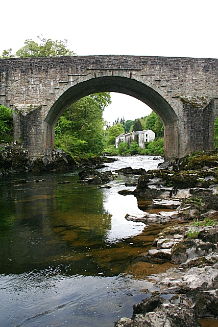
Image: Skipper’s Bridge by Anne Burgess, 17 May 2009, sourced from Wikimedia Commons and licensed under CC BY-SA 2.0.


Three unequal arches carry the historic route across the Esk, combining a late-seventeenth-century core with an early-nineteenth-century widening.
Quick facts
- Date
- 1693–1700; widened about 1807
- Architect / designer
- Makers unrecorded
- Type
- Three-arch rubble road bridge with later widening
- Designation
- Listed building, Category A (LB9764)
- OS grid reference
- NY 37066 83396
Architecture, archaeology and continuing use
Squared rubble and ashlar voussoirs form three segmental arches, the smaller outer spans providing flood relief. Pointed cutwaters, pilaster strips and a stepped corbel table distinguish the older elevation from the widened side.
Its story
A manuscript written in 1726 indicates that the bridge had been built about twenty-six years earlier. Widening around 1807 adapted the crossing for increased road traffic while leaving the earlier masonry readable.
Why it is included
Category A recognition, an unusually early date and uninterrupted transport use make the bridge a major survival in the historic route through Eskdale.
What to notice
- Three arches of unequal size.
- Pointed cutwaters between the spans.
- Different detailing on the original and widened faces.
Reading the surroundings
This is a live trunk-road crossing. Use the lawful pedestrian route, remain alert to traffic and never enter the carriageway or climb the parapets to inspect the masonry.
Timeline
- 1693–1700 The three-arch bridge was constructed across the Esk.
- c.1807 A northward widening increased the road width.
- 2026 The A7 still uses the historic crossing.
What we know — and what remains uncertain
The building date is reconstructed from the 1726 manuscript rather than a surviving datestone or construction account.
Sources & further reading
- Historic Environment Scotland: Skipper’s Bridge, LB9764 — Designation status, mapped location, date, fabric and architectural or archaeological interest.
- Langholm Conservation Area Character Appraisal and Management Plan — Independent local-authority context for the bridge, historic routes and present townscape.
Location
OS grid reference NY 37066 83396 · Location confidence: High: the national designation supplies an official mapped National Grid Reference; the independent source confirms the Place relationship, history or current identity. · Select the marker to open its satellite view in Google Maps. On desktop, drag Pegman (the yellow figure) onto a blue road. On mobile, turn on the Street View layer and tap a blue road. Other photo markers may be user-contributed.
Suggest a marker correction
Suggest a more accurate position
The teal marker is the current published position. The orange marker starts slightly to its right so both remain visible; this is only a visual starting position. Tap the correct place on the map or drag the orange marker. Sending this form creates a private review entry only; it does not move the published marker.
Check this area in Google Maps Choose the Satellite layer there if useful.
Map: © OpenStreetMap contributors. You can also enter checked coordinates below.