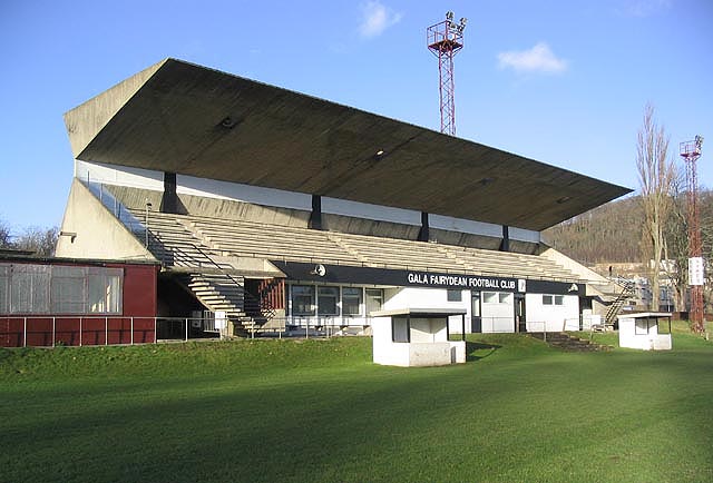
Image: Peter Womersley’s angular concrete football stand at Netherdale in Galashiels, viewed across the pitch by Walter Baxter, licensed under CC BY-SA 2.0.

In these guides: Twentieth-Century Scottish Architecture · Sport and Recreation Architecture in Scotland
A sculptural concrete football stand in which four fins, a wedge-shaped terrace and a cantilevered canopy turn a modest local ground into a major work of Scottish Modernism.
Quick facts
- Date
- Designed 1963–1965; formally opened in November 1964; later alterations and recent repair
- Architect / designer
- Peter Womersley, architect, with Ove Arup, structural engineers
- Type
- Late Modernist football stand and pavilion
- Designation
- Category A listed football stand (LB50711)
- OS grid reference
- NT 50696 35021
Concrete balanced for spectators
Four V-shaped concrete fins support the wedge of seating and the long cantilevered canopy. Seen from the pitch, the roof appears to rest on the narrow rear edge of the terrace, while small inverted-pyramid roofs mark the turnstiles.
Its story
Gala Fairydean commissioned Peter Womersley during a successful period for the club. Working with Ove Arup, he produced a 750-seat stand that opened in November 1964. Later additions changed parts of the ground-floor accommodation; a recent repair programme has addressed the concrete structure and other fabric.
A pavilion beneath the spectators
The stand was conceived with ground-level accommodation and a bar beneath the seating, reached by open-tread concrete stairs at the ends. It therefore combines the viewing structure with a small social and service building. The inverted-pyramid turnstile roofs repeat the main stand’s interest in sharply defined concrete forms at a much smaller scale. The long canopy, wedge of seating and end stairways shape movement through the pavilion as well as its sculptural appearance. Board marks in the concrete record the formwork used to cast it.
What to notice
- The four tapering structural fins.
- The apparent lightness of the long canopy when viewed from the pitch.
- The contrast between original board-marked concrete and later infill or repair work.
- Read the stand from ground-level accommodation through end stairs to seating, and compare the turnstile roofs with the main canopy.
Reading the surroundings
This is an operational sports ground. Viewing, photography and access to the stand must follow club, match-day and safety arrangements.
Timeline
- 1929 Gala Fairydean moved to Nether Road.
- 1963–1965 Peter Womersley and Ove Arup designed and delivered the new stand.
- November 1964 The stand formally opened during construction period recorded by the designation.
- 2006–2013 The stand was listed and later upgraded to Category A.
- 2020s Repair and restoration work addressed the concrete and later alterations.
What we know — and what remains uncertain
Sources use both 1964 and 1965 as completion markers, while the designation gives 1963–1965 and records the November 1964 opening. Current spectator access to particular parts of the stand must be checked with the club.
Sources & further reading
- Historic Environment Scotland: Gala Fairydean Football Stadium, LB50711 — Designation, date, architect, engineer, form and significance.
- Trove: Nether Road football stadium designation — Precise location, designation history and detailed statement of interest.
- Gala Fairydean Rovers: club history — Club history, ground use and the story of funding the stand.
- Gala Fairydean Rovers: the stand — Contemporary accounts of the stand’s opening and accommodation.
Explore further
Location
OS grid reference NT 50696 35021 · Location confidence: High: the designation and Trove record agree on the listed stand and its point. · Select the marker to open its satellite view in Google Maps. On desktop, drag Pegman (the yellow figure) onto a blue road. On mobile, turn on the Street View layer and tap a blue road. Other photo markers may be user-contributed.
Suggest a marker correction
Suggest a more accurate position
The teal marker is the current published position. The orange marker starts slightly to its right so both remain visible; this is only a visual starting position. Tap the correct place on the map or drag the orange marker. Sending this form creates a private review entry only; it does not move the published marker.
Check this area in Google Maps Choose the Satellite layer there if useful.
Map: © OpenStreetMap contributors. You can also enter checked coordinates below.