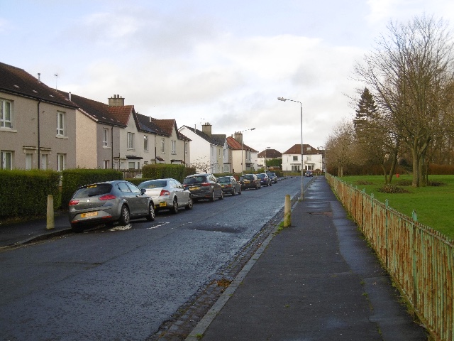
A large municipal suburb combining two-storey housing with shopping centres, schools, churches and recreation grounds.
Quick facts
Date: From 1923
Design and delivery: Glasgow Corporation; municipal direct labour programme
Designation: Estate record; individual buildings have their own designation status
Housing and a suburban plan
Work at Knightswood began in 1923. Glasgow City Archives gives a total of 6,714 homes in the original scheme, built on both sides of Great Western Road. Semi-detached houses, terraces and cottage flats were limited to two storeys.
The plan combined housing with four shopping centres, eight churches and six schools. Sports grounds, tennis, golf and other recreation facilities occupied substantial open areas. A planned community centre had to wait until after the Second World War.
Building at scale
Glasgow Corporation’s Direct Labour Organisation, established in 1920, belonged to the machinery that delivered the expanding municipal programme. Knightswood shows how public housebuilding involved both the repeated dwelling and the provision of a wider neighbourhood.
The photographed houses on Loanfoot Avenue illustrate the domestic scale of this part of the estate. The later high-rise developments elsewhere in Knightswood belong to a different phase of public housing.
Location and Photos
The estate extends across a large area around Great Western Road. The map point marks houses on Loanfoot Avenue.


Explore further
Sources & further reading
- Glasgow City Archives / TheGlasgowStory, Knightswood Housing — Dates, scale, housing types, direct labour and amenities.
- Richard Webb, Loanfoot Avenue, Geograph 4785149 — Photograph and representative house location.
Location
Location confidence: Representative houses on Loanfoot Avenue, using the object location in Geograph 4785149. · Select the marker to open its satellite view in Google Maps. On desktop, drag Pegman (the yellow figure) onto a blue road. On mobile, turn on the Street View layer and tap a blue road. Other photo markers may be user-contributed.
Suggest a marker correction
Suggest a more accurate position
The teal marker is the current published position. The orange marker starts slightly to its right so both remain visible; this is only a visual starting position. Tap the correct place on the map or drag the orange marker. Sending this form creates a private review entry only; it does not move the published marker.
Check this area in Google Maps Choose the Satellite layer there if useful.
Map: © OpenStreetMap contributors. You can also enter checked coordinates below.
In these guides: Public Housing in Scotland: A Photo Guide to Designs and Types