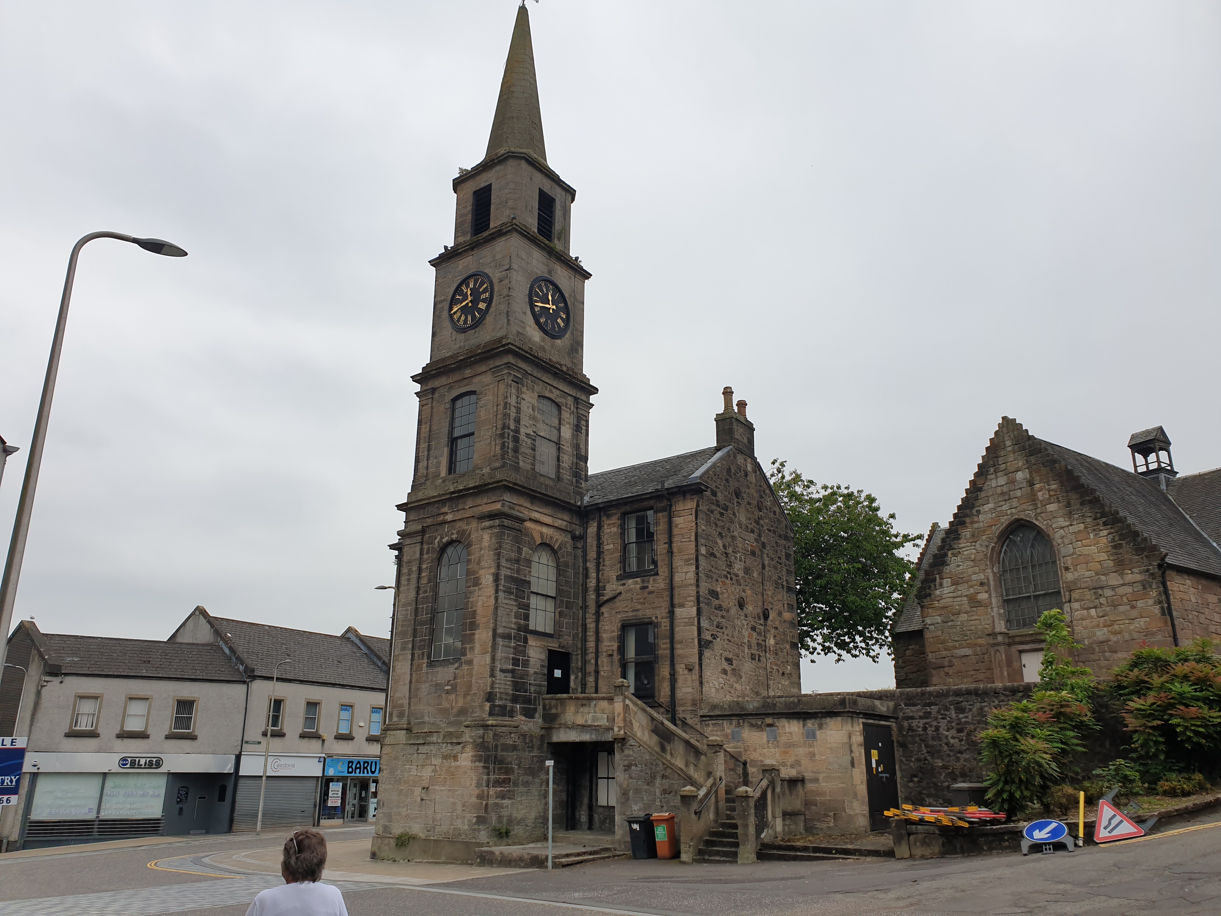


A four-stage clock tower and spire preserve the public identity of Kirkintilloch’s former tolbooth even after its courtroom was dismantled.
Quick facts
- Date
- Rebuilt 1814
- Architect / designer
- Designer not recorded in the current designation
- Type
- Four-stage classical tolbooth tower with clock and spire
- Designation
- Listed building, Category B (LB36648)
- OS grid reference
- NS 65231 74101
Architecture and continuing use
The classical stone tower rises through four stages to a clock and spire. An external forestair reaches the principal building, while a separate tower stair served upper floors, reflecting the controlled circulation needed by a courtroom and burgh offices.
Its story
The tolbooth concentrated justice and local administration in the old burgh centre. Rebuilding in 1814 gave it the present tower. Its courtroom was later removed and legal offices occupied the building, continuing an institutional connection without preserving the original interior function intact.
Why it is included
Category B listing protects a compact civic landmark whose clock, vertical form and former judicial role connect the street with burgh government.
What to notice
- Clock stage immediately below the spire.
- External forestair serving the principal floor.
- Four-part vertical sequence of the classical tower.
Reading the surroundings
View from public streets without blocking doors or the forestair. Do not enter unless the present occupier clearly permits it, and take care around traffic and narrow pavements.
Timeline
- Before 1814 A tolbooth already served justice and government on the site.
- 1814 Rebuilding produced the present clock tower and spire.
- Twentieth century The courtroom was dismantled and professional offices occupied the complex.
What we know — and what remains uncertain
The HES description uses an older office attribution. No claim is made that the named historic firm or any particular occupier remains there in 2026.
Sources & further reading
- Historic Environment Scotland: Kirkintilloch Town Steeple, LB36648 — Current designation status, mapped location, date, fabric and architectural or archaeological interest.
- Trove designation: LB36648 — Parallel national record identity and archival context.
Location
OS grid reference NS 65231 74101 · Location confidence: High: the current national designation supplies an exact mapped National Grid Reference; public text separately states access and current-use uncertainty. · Select the marker to open its satellite view in Google Maps. On desktop, drag Pegman (the yellow figure) onto a blue road. On mobile, turn on the Street View layer and tap a blue road. Other photo markers may be user-contributed.
Suggest a marker correction
Suggest a more accurate position
The teal marker is the current published position. The orange marker starts slightly to its right so both remain visible; this is only a visual starting position. Tap the correct place on the map or drag the orange marker. Sending this form creates a private review entry only; it does not move the published marker.
Check this area in Google Maps Choose the Satellite layer there if useful.
Map: © OpenStreetMap contributors. You can also enter checked coordinates below.