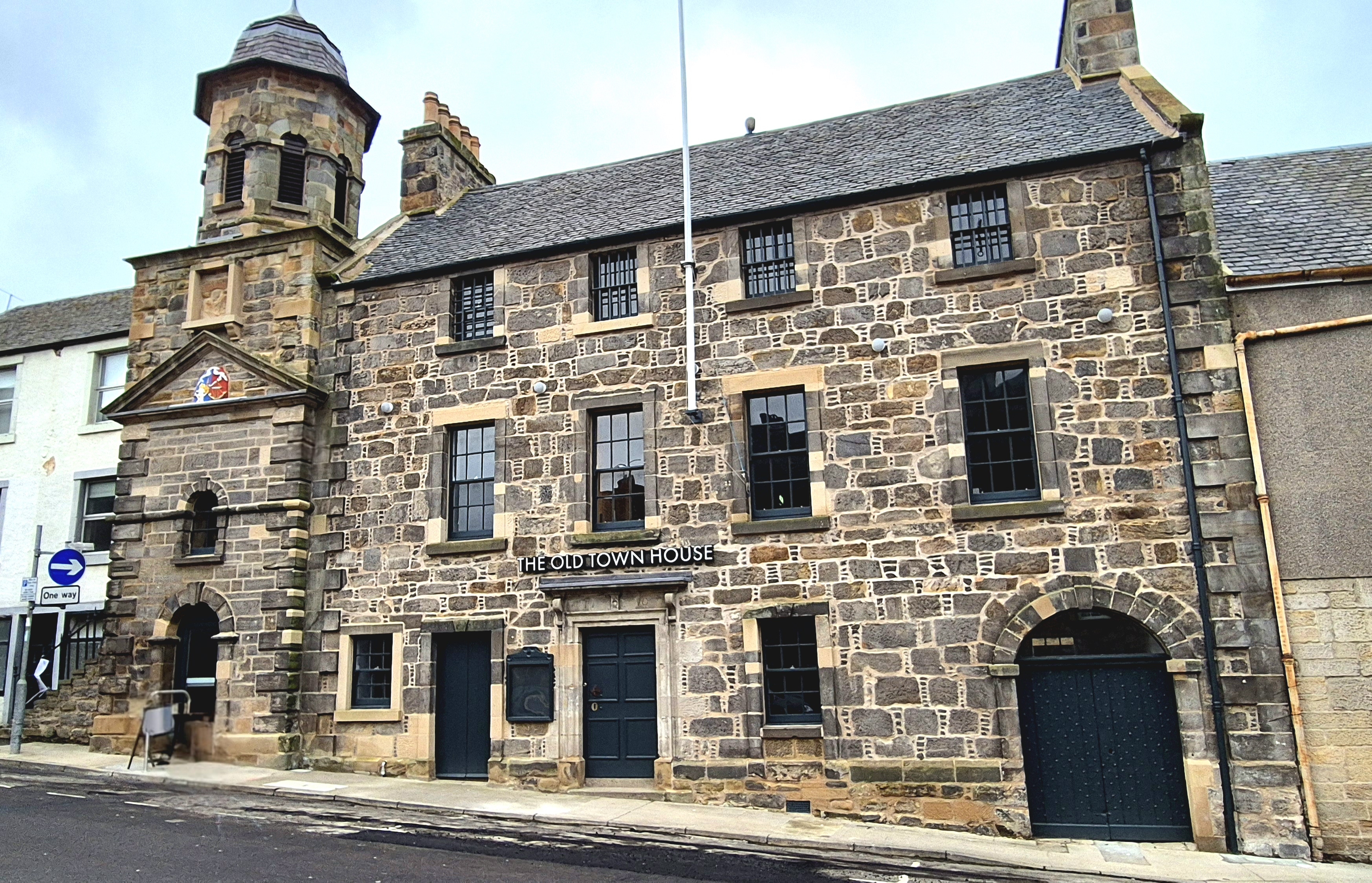
Image: Inverkeithing Town House by Arcaist, sourced from Wikimedia Commons and licensed under CC BY 4.0.

A small royal burgh expressed civic authority through an unusually accomplished town house combining council rooms, prison cells and a landmark belfry.
Quick facts
- Date
- Tower 1754–55; main block 1769–70; community adaptation completed in the 2020s
- Architect / designer
- John Monroe, tower; George Monroe, main block
- Type
- Burgh town house, tolbooth and belfry tower
- Designation
- Listed building, Category A (LB35087)
- OS grid reference
- NT 13040 82924
Architecture and continuing use
The square tower is faced in coursed ashlar and rises to a pediment, octagonal belfry and ogee roof. Beside it, a three-storey main block has a dated central doorway, former pend and barred upper windows once associated with debtors. The interior still broadly follows the eighteenth-century arrangement despite later repair and adaptation.
Its story
Inverkeithing had an earlier tolbooth by 1550, but security and condition prompted replacement. John Monroe built the present tower in 1754–55 and George Monroe added the main block in 1769–70. Rooms served court, council and prison functions. A major heritage project later repaired the building, added accessible circulation and prepared it for community management.
Why it is included
Category A listing protects a distinguished provincial civic building whose fabric makes local government, justice and public assembly legible.
What to notice
- Ogee-roofed belfry rising above the stepped town roofline.
- Barred square openings of the former debtors’ rooms.
- Dated doorway and former pend beside the churchyard.
Reading the surroundings
Use advertised community events once operation begins. Until then, view from public streets, respect works or handover restrictions and do not assume that a completed restoration means unscheduled interior access.
Timeline
- 1754–55 John Monroe erected the new square civic tower and belfry.
- 1769–70 George Monroe completed the adjoining court and council block.
- 1777 Upper rooms were altered to improve accommodation for debtors.
- 2022–26 Heritage-led repairs and adaptation prepared the building for community use.
What we know — and what remains uncertain
The 2026 council update described the building as nearing handover; opening dates and room availability should be checked with the operator.
Sources & further reading
- Historic Environment Scotland: Inverkeithing Town House, LB35087 — Current designation status, mapped location, date, fabric and architectural interest.
- Trove designation: LB35087 — Parallel national record identity and archival context.
- Fife Council: cash boost to help Inverkeithing Town House open — Current operational status, community management and planned activities.
Location
OS grid reference NT 13040 82924 · Location confidence: High: the current national designation supplies an exact mapped National Grid Reference; public text separately states access and current-use uncertainty. · Select the marker to open its satellite view in Google Maps. On desktop, drag Pegman (the yellow figure) onto a blue road. On mobile, turn on the Street View layer and tap a blue road. Other photo markers may be user-contributed.
Suggest a marker correction
Suggest a more accurate position
The teal marker is the current published position. The orange marker starts slightly to its right so both remain visible; this is only a visual starting position. Tap the correct place on the map or drag the orange marker. Sending this form creates a private review entry only; it does not move the published marker.
Check this area in Google Maps Choose the Satellite layer there if useful.
Map: © OpenStreetMap contributors. You can also enter checked coordinates below.