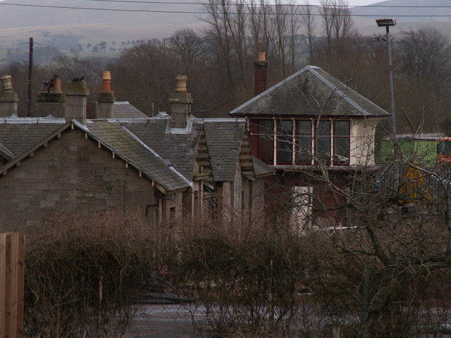


Station, signal box, goods shed and service buildings preserve an unusually complete rural railway ensemble despite vacancy and condition concerns.
Quick facts
- Date
- 1859; enlarged 1906
- Architect / designer
- Caledonian Railway and associated engineers
- Type
- Former railway station group
- Designation
- Listed building, Category B (LB44553)
- OS grid reference
- NT 03951 37259
Architecture, archaeology and continuing use
The principal sandstone station has a low U-plan, deep eaves and surviving domestic details. A brick signal box, timber goods shed, outbuildings and remnants of platforms allow the operational layout to be read as a group.
Its story
The station opened with the Symington–Broughton railway in 1859 and expanded for heavier traffic in 1906. Passenger and goods functions ended, leaving a rare group whose condition and fragmented reuse have prompted long-running concern.
Why it is included
The survival of several complementary railway structures gives the record greater evidential value than an isolated station building.
What to notice
- Low sandstone passenger building.
- Red-brick signal box with a glazed upper cabin.
- Goods shed, service buildings and platform traces.
Reading the surroundings
The former station is not a public attraction and parts are vacant or in poor condition. Observe only from lawful public space, keep clear of work and storage areas, and never enter buildings, tracksides or fenced land.
Timeline
- 1859 The station opened with the new railway between Symington and Broughton.
- 1906 Caledonian Railway enlargement added capacity and a new signal box.
- 2026 Current visitor information still identifies the surviving station and signal box.
What we know — and what remains uncertain
Occupancy and repair activity can change quickly; no interior access or safe public entry is implied by mapping or listing.
Sources & further reading
- Historic Environment Scotland: Former Biggar Railway Station, LB44553 — Designation status, mapped location, date, fabric and architectural or archaeological interest.
- Visit Lanarkshire: Biggar — Current public recognition of the surviving station, signal box and former railway path.
Location
OS grid reference NT 03951 37259 · Location confidence: High: the national designation supplies an official mapped National Grid Reference; the independent source confirms the Place relationship, history or current identity. · Select the marker to open its satellite view in Google Maps. On desktop, drag Pegman (the yellow figure) onto a blue road. On mobile, turn on the Street View layer and tap a blue road. Other photo markers may be user-contributed.
Suggest a marker correction
Suggest a more accurate position
The teal marker is the current published position. The orange marker starts slightly to its right so both remain visible; this is only a visual starting position. Tap the correct place on the map or drag the orange marker. Sending this form creates a private review entry only; it does not move the published marker.
Check this area in Google Maps Choose the Satellite layer there if useful.
Map: © OpenStreetMap contributors. You can also enter checked coordinates below.