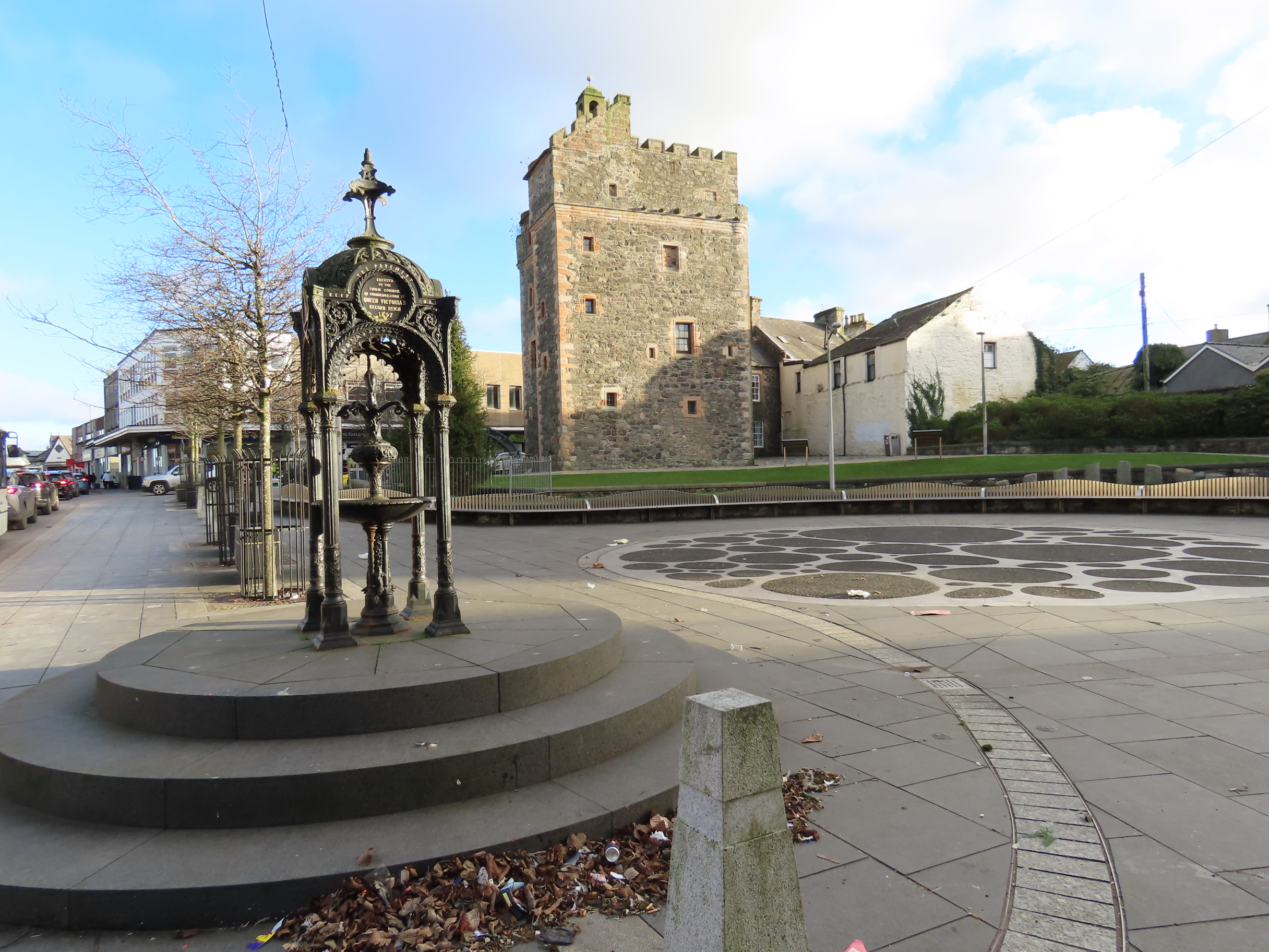
Image: Tower of the Castle of St John in central Stranraer, seen beyond the town’s ornate war memorial by Billy McCrorie, licensed under CC BY-SA 2.0.

A robust tower house at the centre of town preserves vaulted rooms, gunloops and the iron-plated doors of its later life as a jail.
Quick facts
- Date
- About 1510; attic added about 1600; converted to a town jail in 1821
- Architect / designer
- Built for Ninian Adair of Kinhilt; individual builders not identified
- Type
- L-plan tower house with vaulted rooms, turnpike stair and later prison cells
- Designation
- Listed building, Category A (LB41765)
- OS grid reference
- NX 06090 60821
Architecture and continuing use
Rubble walls with red-sandstone dressings rise through three storeys and an attic behind a castellated parapet. An advanced stair tower, turnpike stair, vaulted chambers, gunloops and later cells concentrate several phases in a compact plan.
Its story
The Adair family built the tower around 1510. An attic followed around 1600, and the burgh converted it to a jail in 1821. Restoration in 1988–1990 created the present visitor attraction.
Why it is included
It is Stranraer’s oldest substantial building and explains the burgh’s development through domestic power, defence, punishment and public interpretation.
What to notice
- Red sandstone quoins against rubble walls.
- Advanced stair tower and roof-level caphouse.
- Vaulted cells and iron-plated doors where authorised access allows.
Reading the surroundings
DG Culture publishes seasonal opening times. The historic stair is steep and the roof and upper rooms may not suit every visitor; ask staff about access.
Timeline
- About 1510 The Adair family built the tower around 1510. An attic followed around 1600, and the burgh converted it to a jail in 1821. Restoration in 1988–1990 created the present visitor attraction.
- Present Seasonally open council heritage attraction and visitor centre.
What we know — and what remains uncertain
The HES designation records the visitor-centre conversion, while exact daily access remains seasonal and should be checked.
Sources & further reading
- Historic Environment Scotland: Castle of St John, LB41765 — Designation status, mapped location, construction phases, fabric, authorship and architectural or historical interest.
- DG Culture: Castle of St John — Current council attraction, seasonal visitor use, address and contact details.
- Dumfries and Galloway Council: Castle of St John booklet — Council historical interpretation and visitor context.
Location
OS grid reference NX 06090 60821 · Location confidence: High: the statutory designation supplies an official mapped National Grid Reference and the current source confirms the Place relationship or present identity. · Select the marker to open its satellite view in Google Maps. On desktop, drag Pegman (the yellow figure) onto a blue road. On mobile, turn on the Street View layer and tap a blue road. Other photo markers may be user-contributed.
Suggest a marker correction
Suggest a more accurate position
The teal marker is the current published position. The orange marker starts slightly to its right so both remain visible; this is only a visual starting position. Tap the correct place on the map or drag the orange marker. Sending this form creates a private review entry only; it does not move the published marker.
Check this area in Google Maps Choose the Satellite layer there if useful.
Map: © OpenStreetMap contributors. You can also enter checked coordinates below.