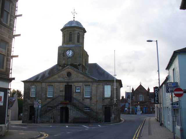
Image: Sanquhar Tolbooth and Museum by Colin Smith, sourced from Wikimedia Commons and licensed under CC BY-SA 2.0.

William Adam’s compact Baroque tolbooth, forestair and belfry dominate Sanquhar High Street and now house the town museum.
Quick facts
- Date
- Begun 1735
- Architect / designer
- William Adam
- Type
- Baroque tolbooth, council chamber and prison
- Designation
- Listed building, Category A (LB40540)
- OS grid reference
- NS 78090 09913
Architecture, archaeology and continuing use
A five-bay two-storey front is enlivened by a central forestair, pediment and belfry. Cells and public rooms preserve the building’s combined judicial, administrative and ceremonial programme.
Its story
The burgh commissioned a replacement tolbooth in the 1730s, reportedly reusing stone from Sanquhar Castle. Later alterations included the forestair railings, and museum use brought the building back into public interpretation.
Why it is included
Category A status, William Adam authorship and continuing civic use make it the architectural anchor of Sanquhar.
What to notice
- External forestair rising to the principal floor.
- Central pediment and open belfry.
- Surviving cell doorway within the public interior.
Reading the surroundings
The council confirms museum service during the 2026 conservation programme, but temporary arrangements and road closures may change. Check before visiting.
Timeline
- 1731 The burgh resolved to replace its inadequate tolbooth.
- 1735 Work began on William Adam’s Baroque town house.
- 1857 New ironwork was fitted around the forestair.
- 2026 Conservation work proceeded while museum provision continued.
What we know — and what remains uncertain
Museum access may vary during the council’s 2026 structural and conservation works.
Sources & further reading
- Historic Environment Scotland: Sanquhar Tolbooth and Museum, LB40540 — Designation status, official mapped location, date, fabric and architectural or archaeological interest.
- Dumfries and Galloway Council: Sanquhar Tolbooth works — Current conservation work, museum continuity and visitor disruption.
Location
OS grid reference NS 78090 09913 · Location confidence: High: the national designation supplies an official mapped National Grid Reference and the second source confirms the Place relationship, history or current identity. · Select the marker to open its satellite view in Google Maps. On desktop, drag Pegman (the yellow figure) onto a blue road. On mobile, turn on the Street View layer and tap a blue road. Other photo markers may be user-contributed.
Suggest a marker correction
Suggest a more accurate position
The teal marker is the current published position. The orange marker starts slightly to its right so both remain visible; this is only a visual starting position. Tap the correct place on the map or drag the orange marker. Sending this form creates a private review entry only; it does not move the published marker.
Check this area in Google Maps Choose the Satellite layer there if useful.
Map: © OpenStreetMap contributors. You can also enter checked coordinates below.