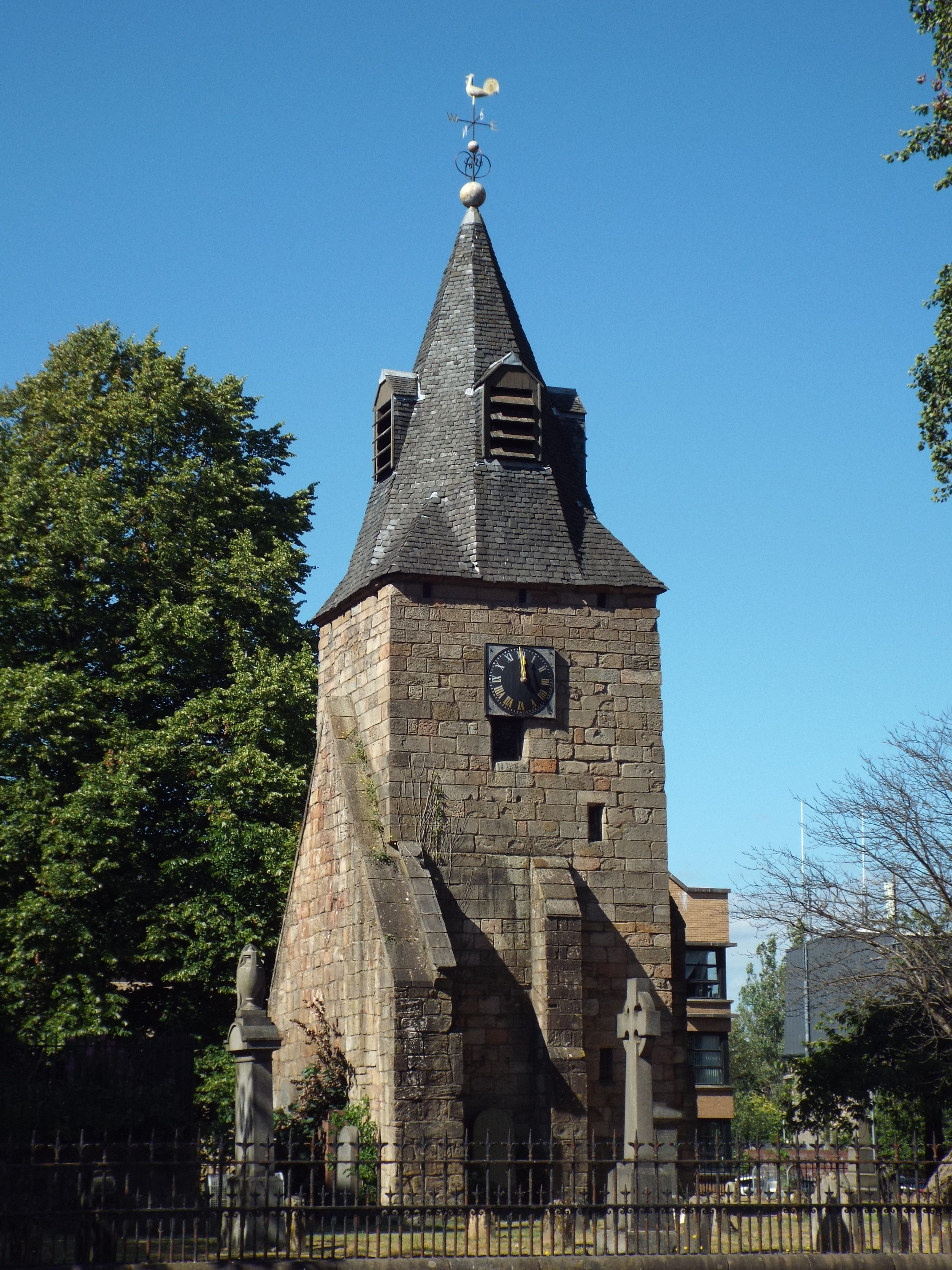
Image: Rutherglen Tower and fragments of the old church by BrainiacBlink, 9 July 2018, sourced from Wikimedia Commons and licensed under CC BY-SA 4.0.

A late-medieval square tower, 1710 spire and surviving east gable keep the earlier parish church visible beside Rutherglen’s present kirk.
Quick facts
- Date
- Late medieval fabric; tower heightened and spire added in 1710
- Architect / designer
- Medieval builders unknown; 1710 work not attributed
- Type
- Medieval church tower and fragmentary church fabric
- Designation
- Listed building, Category A (LB33563)
- OS grid reference
- NS 61331 61705
Architecture and continuing use
The ashlar tower is braced by buttresses and pierced by chamfered openings. Its upper stage carries a clock and rises to a slated broach spire with gilded balls and a weathercock. A surviving east gable and loose stone base make the fragmentary church plan partly legible.
Its story
The remains belong to the church that preceded the present parish building and may incorporate still earlier masonry. The tower was heightened and given its spire in 1710. Its bell was cast in 1635 by Michael Burgerhuys in Middelburg, while carved stones from the site, including twelfth-century capitals, entered the local museum collection.
Why it is included
Category A listing recognises exceptionally important medieval burgh fabric, later civic clock and bell history, and the visible continuity of worship and commemoration on this site.
What to notice
- The change in proportion created by the 1710 upper work and spire.
- Buttresses and chamfered openings in the square medieval tower.
- The detached east gable and other fragments that outline the former church.
Reading the surroundings
The council records open access to the churchyard grounds. Do not assume the tower interior is open, climb masonry or disturb memorials; respect services and funerary activity nearby.
Timeline
- 1635 Michael Burgerhuys cast the bell that survives in the tower.
- 1710 Builders raised the tower and added its present broach spire.
- 1841 Rutherglen acquired a reused Glasgow clock for the steeple.
- 2026 The council continues to manage open access to the closed historic churchyard.
What we know — and what remains uncertain
The earliest phases are not precisely dated, and the fabric may include material older than the late-medieval tower. Open churchyard access does not establish tower-interior access.
Sources & further reading
- Historic Environment Scotland: Rutherglen Old Church Tower and Fragments, LB33563 — Current designation status, official mapped location, date, fabric and architectural interest.
- Trove designation: LB33563 — Parallel national record identity and archival context.
- South Lanarkshire Council: Rutherglen Old Parish Churchyard — First-party current access, management and churchyard information.
- South Lanarkshire Council: Rutherglen Conservation Area Character Appraisal — Official planning context for the tower, church fragments and medieval burgh core.
Location
OS grid reference NS 61331 61705 · Location confidence: High: the current national designation supplies an exact mapped National Grid Reference; public text separately states access and current-use uncertainty. · Select the marker to open its satellite view in Google Maps. On desktop, drag Pegman (the yellow figure) onto a blue road. On mobile, turn on the Street View layer and tap a blue road. Other photo markers may be user-contributed.
Suggest a marker correction
Suggest a more accurate position
The teal marker is the current published position. The orange marker starts slightly to its right so both remain visible; this is only a visual starting position. Tap the correct place on the map or drag the orange marker. Sending this form creates a private review entry only; it does not move the published marker.
Check this area in Google Maps Choose the Satellite layer there if useful.
Map: © OpenStreetMap contributors. You can also enter checked coordinates below.