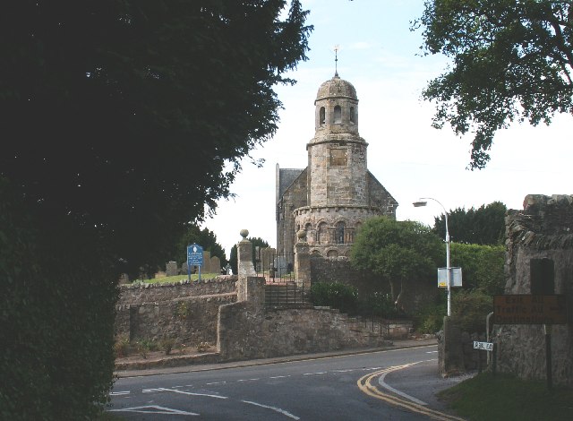
Image: Parish Kirk of St Athernase by Jim Bain, sourced from Wikimedia Commons and licensed under CC BY-SA 2.0.

One of Scotland’s most complete Romanesque chancels and apses survives at the heart of a church still used for worship.
Quick facts
- Date
- c.1183–1187; consecrated 1244; later alterations
- Architect / designer
- Robert Balfour, 1812–1814; John Milne, 1858; Reginald Fairlie, 1914 and 1922
- Type
- Romanesque parish church
- Designation
- Listed building, Category A (LB8842)
- OS grid reference
- NO 45542 21394
Architecture and continuing use
Two levels of blind arcading wrap the ashlar chancel and rounded apse beneath a carved corbel table. The nave is plainer and later, incorporating a Victorian Romanesque south front, galleries and work by several nineteenth- and twentieth-century architects.
Its story
The eastern church was probably built in the 1180s and the building was consecrated in 1244. Robert Balfour altered the nave in 1812–1814, John Milne rebuilt much of it in 1858, and Reginald Fairlie reopened the chancel in 1914 before designing the font in 1922.
Why it is included
Category A listing recognises the exceptional survival and sculptural quality of the Romanesque work, together with the building’s long, continuing ecclesiastical history.
What to notice
- Interlaced blind arcading around the chancel.
- The rounded apse and its sculptured corbel table.
- The contrast between medieval sanctuary and later nave.
Reading the surroundings
This is an active church. Check the congregation’s current service or visitor information, enter only when invited or advertised, and respect worship, funerals and private events.
Timeline
- c.1183–1187 Builders created the Romanesque chancel and rounded apse.
- 1244 The church was formally consecrated.
- 1858 John Milne rebuilt much of the nave while retaining medieval fabric.
- 1914–1922 Reginald Fairlie reopened the chancel and later designed the font.
What we know — and what remains uncertain
The exact start and completion dates of the Romanesque work remain approximate, and not every phase can be assigned securely to a named designer.
Sources & further reading
- Historic Environment Scotland: Parish Kirk of St Athernase, LB8842 — Current designation status, mapped location, date, fabric and architectural or archaeological interest.
- Trove designation: LB8842 — Parallel national record identity and archival context.
- Leuchars and Tayport Church of Scotland — Current congregational identity, service information and continuing use.
- Scotland’s Churches Trust: St Athernase — Independent church-access and architectural context.
Location
OS grid reference NO 45542 21394 · Location confidence: High: the current national designation supplies an exact mapped National Grid Reference; public text separately states access and current-use uncertainty. · Select the marker to open its satellite view in Google Maps. On desktop, drag Pegman (the yellow figure) onto a blue road. On mobile, turn on the Street View layer and tap a blue road. Other photo markers may be user-contributed.
Suggest a marker correction
Suggest a more accurate position
The teal marker is the current published position. The orange marker starts slightly to its right so both remain visible; this is only a visual starting position. Tap the correct place on the map or drag the orange marker. Sending this form creates a private review entry only; it does not move the published marker.
Check this area in Google Maps Choose the Satellite layer there if useful.
Map: © OpenStreetMap contributors. You can also enter checked coordinates below.