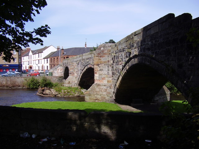
Image: Old Bridge, Musselburgh by james denham, 22 August 2007, sourced from Wikimedia Commons and licensed under CC BY-SA 2.0.


A narrow three-arched bridge carries pedestrians across the Esk and preserves a route long associated with the old burgh.
Quick facts
- Date
- Early 16th century; repaired 1597
- Architect / designer
- Attributed by tradition to the wife of Lord Seton; masons unrecorded
- Type
- Three-arched masonry bridge
- Designation
- Listed building, Category A (LB38378)
- OS grid reference
- NT 34076 72537
Architecture, archaeology and continuing use
Three low segmental arches of coursed rubble meet V-plan cutwaters with pedestrian refuges. Stepped approaches and a splayed bridgehead emphasise the narrow, pre-modern character of the crossing.
Its story
The surviving bridge is principally early sixteenth century and was repaired under an Act of Parliament in 1597, when the third arch may have been added. Modern road bridges removed heavy traffic and allowed continued pedestrian use.
Why it is included
The Category A bridge is a rare early civic crossing and a physical link between river, route history and burgh development.
What to notice
- Three segmental arches of differing alignment.
- V-plan cutwaters and refuges.
- Stepped approaches within the bridgeheads.
Reading the surroundings
Use the pedestrian crossing carefully, especially when surfaces are wet or icy. Do not climb parapets, enter the river or rely on the traditional “Roman Bridge” name as a construction date.
Timeline
- Early 16th century Masons formed the principal surviving arches across the Esk.
- 1597 Parliament authorised repairs and probably the additional landward arch.
- 1971 The bridge entered the national listed-building register.
- 1998 Scheduling was removed while Category A protection continued.
What we know — and what remains uncertain
Attribution to Lord Seton’s wife is traditional, and the precise relationship between the original arches and the 1597 work remains uncertain.
Sources & further reading
- Historic Environment Scotland: Old Bridge, Musselburgh, LB38378 — Designation status, mapped location, date, fabric and architectural or archaeological interest.
- Trove: Musselburgh Old Bridge — National archaeological record, mapped identity, archive material and bibliography for the crossing.
Location
OS grid reference NT 34076 72537 · Location confidence: High: the national designation supplies an official mapped National Grid Reference; the independent source confirms the Place relationship, history or current identity. · Select the marker to open its satellite view in Google Maps. On desktop, drag Pegman (the yellow figure) onto a blue road. On mobile, turn on the Street View layer and tap a blue road. Other photo markers may be user-contributed.
Suggest a marker correction
Suggest a more accurate position
The teal marker is the current published position. The orange marker starts slightly to its right so both remain visible; this is only a visual starting position. Tap the correct place on the map or drag the orange marker. Sending this form creates a private review entry only; it does not move the published marker.
Check this area in Google Maps Choose the Satellite layer there if useful.
Map: © OpenStreetMap contributors. You can also enter checked coordinates below.