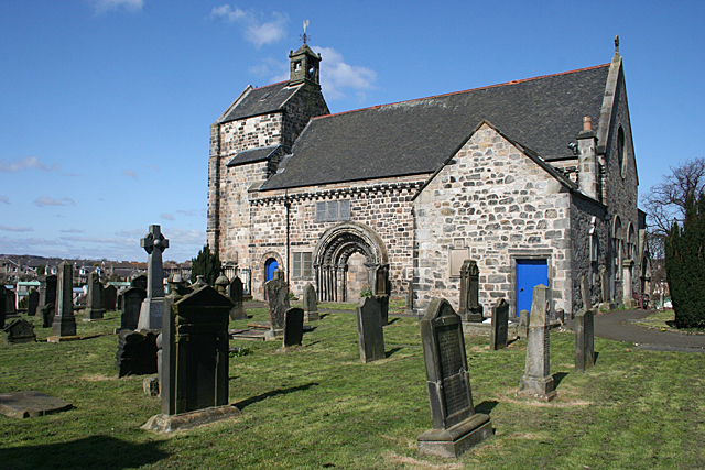
Image: Kirkliston Parish Kirk by Anne Burgess, 1 April 2012, sourced from Wikimedia Commons and licensed under CC BY-SA 2.0.

One of the Lothians’ most important surviving Romanesque churches remains the architectural and spiritual focus of Kirkliston.
Quick facts
- Date
- Late twelfth century; altered in the seventeenth century, 1822 and 1883
- Architect / designer
- Medieval builders not recorded; later work by R. Rowand Anderson
- Type
- Romanesque parish church with tower, aisles, watch house, graveyard walls and gatepiers
- Designation
- Listed building, Category A (LB27457)
- OS grid reference
- NT 12480 74379
Architecture and continuing use
The church retains a late twelfth-century nave and west tower in squared sandstone. A richly ordered south doorway combines nook shafts, water-leaf capitals and deeply cut chevron ornament. Later aisles, galleries and the east porch surround the medieval core, while the truncated tower carries a saddleback roof and former dovecot. An early nineteenth-century watch house, graveyard walls and Doric gatepiers complete the group.
Its story
The medieval church originally had an unaisled nave, western tower and chancel. The tower was reduced in the seventeenth century, when a stone belfry was added; its bell is dated 1687. The south door was blocked when the north aisle was built in 1822. R. Rowand Anderson moved and remodelled the main entrance during work in 1883. The building continues in parish use.
Why it is included
Its surviving Romanesque masonry, later congregational alterations and continuing worship make the church an unusually rich record of more than eight centuries of use.
What to notice
- Deep chevron carving around the blocked Romanesque south doorway.
- The short saddleback tower with belfry, flight holes and traces of its dovecot use.
- Watch house, gatepiers and gravestones with carved memento-mori symbols.
Reading the surroundings
Consult the congregation for services and opening arrangements. Respect worship, funerals, graves and memorials, and do not climb or touch vulnerable medieval stonework.
Timeline
- Late 12th century The Romanesque nave and western tower were built.
- 1687 John Meikle of Edinburgh cast the bell that remains associated with the tower.
- 1822 A new north aisle changed circulation and the ornate south door was blocked.
- 1883 R. Rowand Anderson directed another major phase of enlargement and entrance work.
What we know — and what remains uncertain
Successive rebuilding has obscured the full plan of the twelfth-century church, and the lost chancel is known through fabric and historical study rather than a complete standing outline.
Sources & further reading
- Historic Environment Scotland: Kirkliston Parish Church, LB27457 — Current designation status, statutory identity, official mapped point, date, fabric and significance.
- Kirkliston Parish Church: about the church — Current congregational evidence for continuing worship and the church’s historical development.
- Trove: Kirkliston Parish Church — National heritage inventory, mapped location, archaeological observations and archive references for the church and burial ground.
- National Records of Scotland: Kirkliston parish church records — National archival catalogue evidence for the institutional continuity and historical record of the parish church.
Location
OS grid reference NT 12480 74379 · Location confidence: High for the current HES designation point; public text separately qualifies access, component identity and current use. · Select the marker to open its satellite view in Google Maps. On desktop, drag Pegman (the yellow figure) onto a blue road. On mobile, turn on the Street View layer and tap a blue road. Other photo markers may be user-contributed.
Suggest a marker correction
Suggest a more accurate position
The teal marker is the current published position. The orange marker starts slightly to its right so both remain visible; this is only a visual starting position. Tap the correct place on the map or drag the orange marker. Sending this form creates a private review entry only; it does not move the published marker.
Check this area in Google Maps Choose the Satellite layer there if useful.
Map: © OpenStreetMap contributors. You can also enter checked coordinates below.