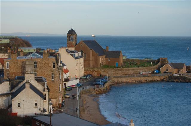


A layered parish kirk combines seventeenth-century aisles, an eighteenth-century nave and a distinctive 1894 chancel and ogee-capped tower.
Quick facts
- Date
- Sailor’s Aisle repaired 1608–1609; major rebuilding 1774; west front, chancel and tower 1894; sanctuary renewed 1937
- Architect / designer
- George Paterson with Roger Black and Robert Kilgour; 1894 work by Sydney Mitchell & Wilson
- Type
- Cruciform, aisled parish church with bell tower and adjoining medieval ruin
- Designation
- Listed building, Category B (LB36241)
- OS grid reference
- NT 27167 86951
Architecture and continuing use
The church is cruciform and galleried, with a broad west gable, Venetian and rose windows, coloured glass and a three-stage bell tower finished by a cross-topped ogee cap. Inside, fixed pews, a ribbed ceiling, gallery on cast-iron columns, organ, chancel arch and memorial furnishings preserve several phases. The projecting Sailor’s and Balmuto aisles retain distinct identities within the larger body of the kirk.
Its story
The site carries worship from the medieval parish into the present. The Sailor’s Aisle was repaired in 1608–1609, the Balmuto Aisle and main body were rebuilt in 1774, and Sydney Mitchell & Wilson reshaped the west end in 1894. A 1937 sanctuary reconstruction added another layer. In January 2024 the Kinghorn and Burntisland congregations united, while continuing worship in both towns.
Why it is included
Few small Scottish coastal churches display medieval continuity, burgh, lairdly and seafaring associations, Victorian remodelling and active worship so legibly in one compact group.
What to notice
- The ogee cap and small belfry openings of the tower.
- The Sailor’s Aisle screen, naval memorial glass and model of HMS Unicorn.
- The Balmuto Aisle’s carved rebuilding tablet and fragments of medieval grave slab.
Reading the surroundings
The church is active rather than a continuously open museum. Scotland’s Churches Trust lists Sunday worship at 10.30am, with the first Sunday normally in the hall, and states that other opening is by arrangement. Check the united congregation’s current service schedule because joint services can change the location. Respect worship, funerals and the adjoining graveyard.
Timeline
- 1608–1609 The Sailor’s Aisle was repaired.
- 1774 George Paterson’s campaign rebuilt the nave and Balmuto Aisle.
- 1894 Sydney Mitchell & Wilson added the west front, chancel and tower.
- 2024 The Burntisland and Kinghorn congregations united while retaining worship in both towns.
What we know — and what remains uncertain
The fabric records several rebuildings, and not every visible detail belongs to the date attached to its aisle. Service times and visitor arrangements are current operational information and should be checked before travel.
Sources & further reading
- Historic Environment Scotland: Kinghorn Parish Church, LB36241 — Designation, grid reference, building phases, exterior, interior, stained glass and special interest.
- Burntisland and Kinghorn Church of Scotland — Current congregational identity and service programme.
- Scotland’s Churches Trust: Kinghorn Parish Church — Visitor overview, worship time and opening by arrangement.
- Fife Council: Kinghorn Conservation Area Appraisal — Townscape context and landmark role.
Location
OS grid reference NT 27167 86951 · Location confidence: High: the statutory or official source supplies an exact National Grid Reference and confirms the Kinghorn identity. · Select the marker to open its satellite view in Google Maps. On desktop, drag Pegman (the yellow figure) onto a blue road. On mobile, turn on the Street View layer and tap a blue road. Other photo markers may be user-contributed.
Suggest a marker correction
Suggest a more accurate position
The teal marker is the current published position. The orange marker starts slightly to its right so both remain visible; this is only a visual starting position. Tap the correct place on the map or drag the orange marker. Sending this form creates a private review entry only; it does not move the published marker.
Check this area in Google Maps Choose the Satellite layer there if useful.
Map: © OpenStreetMap contributors. You can also enter checked coordinates below.