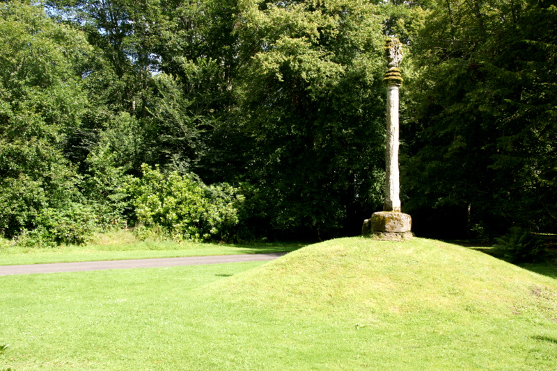
Image: Cross of Old Scone by Mike Pennington, sourced from Wikimedia Commons and licensed under CC BY-SA 2.0.

A slender octagonal shaft and foliated head preserve the civic symbol of Old Scone within the palace landscape.
Quick facts
- Date
- Medieval, with later relocation and repair
- Architect / designer
- Unknown medieval masons
- Type
- Octagonal medieval market cross
- Designation
- Listed building, Category A (LB19876)
- OS grid reference
- NO 11580 26652
Architecture and continuing use
The stone cross consists of an octagonal shaft, moulded capital and foliated cross, with additional fragments gathered at its base. Its scale is modest beside the palace but its form remains legible.
Its story
The cross belonged to the medieval settlement of Scone and was later moved into the palace grounds. It now forms part of the designed landscape experienced by visitors.
That landscape was made by clearing an inhabited community. In about 1804–05, during David Murray, 3rd Earl of Mansfield’s enlargement of Scone Palace’s grounds, Old Scone was cleared and its population transferred to the planned village of New Scone. This was a forced relocation: residents were displaced so the estate could create its park, not simply drawn away by gradual change. The sources record the transfer but do not explain individual consent, compensation, eviction procedures or resistance; they establish displacement, not physical violence. Most of the village was demolished. The market cross and burial ground remained, while the parish church was dismantled and rebuilt at New Scone using as much of its stone as possible.
Why it is included
It links the vanished burgh, medieval civic authority and the modern visitor landscape in one small surviving structure.
What to notice
- The change from octagonal shaft to moulded capital.
- Foliated carving on the cross head.
- Loose or reset fragments at the base.
Visiting and access
The cross stands within the ticketed Scone Palace gardens, where the operator’s current map identifies it as the Mercat Cross beside the former village and graveyard. For the 2026 main season, the Palace and Gardens are open daily from 1 April to 31 October, 10am–5.30pm, with last entry at 4pm. Gardens-only admission is available; opening after 31 October is more limited and should be checked before travel. Remain on visitor routes and do not climb on or touch the carved stone. The operator publishes separate accessibility information, but does not give a monument-specific route assessment for the cross, so visitors with particular mobility requirements should check before booking.
Timeline
- Medieval, with later relocation and repair The cross belonged to the medieval settlement of Scone and was later moved into the palace grounds. It now forms part of the designed landscape experienced by visitors.
- c.1804–05 Old Scone was cleared during the enlargement of Scone Palace’s designed grounds, and its population was transferred to planned New Scone.
- Present Historic monument within the publicly visited grounds of Scone Palace.
What we know — and what remains uncertain
The cross’s medieval date remains broad, and it has been moved and repaired; its present setting is not its original market-place context. The estate-led clearance of Old Scone and transfer of its inhabitants are documented, but the sources consulted do not describe individual consent, compensation, eviction procedures or resistance. “Forced relocation” here describes the imposed removal of an inhabited settlement; the records do not establish physical violence.
Sources & further reading
- Historic Environment Scotland: Cross of Old Scone, LB19876 — Designation category, mapped location, construction phases, fabric, authorship and architectural interest.
- Scone Palace: plan your visit — Current public access, seasonal opening, ticketing and visitor context for the palace grounds.
- Scone Palace gardens map — Operator map identifying the Mercat Cross within the visitor landscape.
- Historic Environment Scotland: Scone Palace, GDL00338 — Records John Claudius Loudon’s c.1804 proposals and the village’s removal to New Scone.
- Historic Environment Scotland: Scone Old Parish Church, LB18361 — States that the old village was demolished for the enlarged estate and that the church was dismantled and re-erected at New Scone.
- National Records of Scotland: Records of Scone Kirk Session, CH2/803 — Records the village’s removal in 1805 and the population’s transfer to planned New Scone.
- New Statistical Account of Scotland: Parish of Scone (1834–45) — Describes the parish church’s 1804 move to New Scone and notes that most of the population was then there.
Location
OS grid reference NO 11580 26652 · Location confidence: High: the HES designation supplies a mapped National Grid Reference and a current operator, council, congregation or institutional source confirms the Place relationship and present identity. · Select the marker to open its satellite view in Google Maps. On desktop, drag Pegman (the yellow figure) onto a blue road. On mobile, turn on the Street View layer and tap a blue road. Other photo markers may be user-contributed.
Suggest a marker correction
Suggest a more accurate position
The teal marker is the current published position. The orange marker starts slightly to its right so both remain visible; this is only a visual starting position. Tap the correct place on the map or drag the orange marker. Sending this form creates a private review entry only; it does not move the published marker.
Check this area in Google Maps Choose the Satellite layer there if useful.
Map: © OpenStreetMap contributors. You can also enter checked coordinates below.