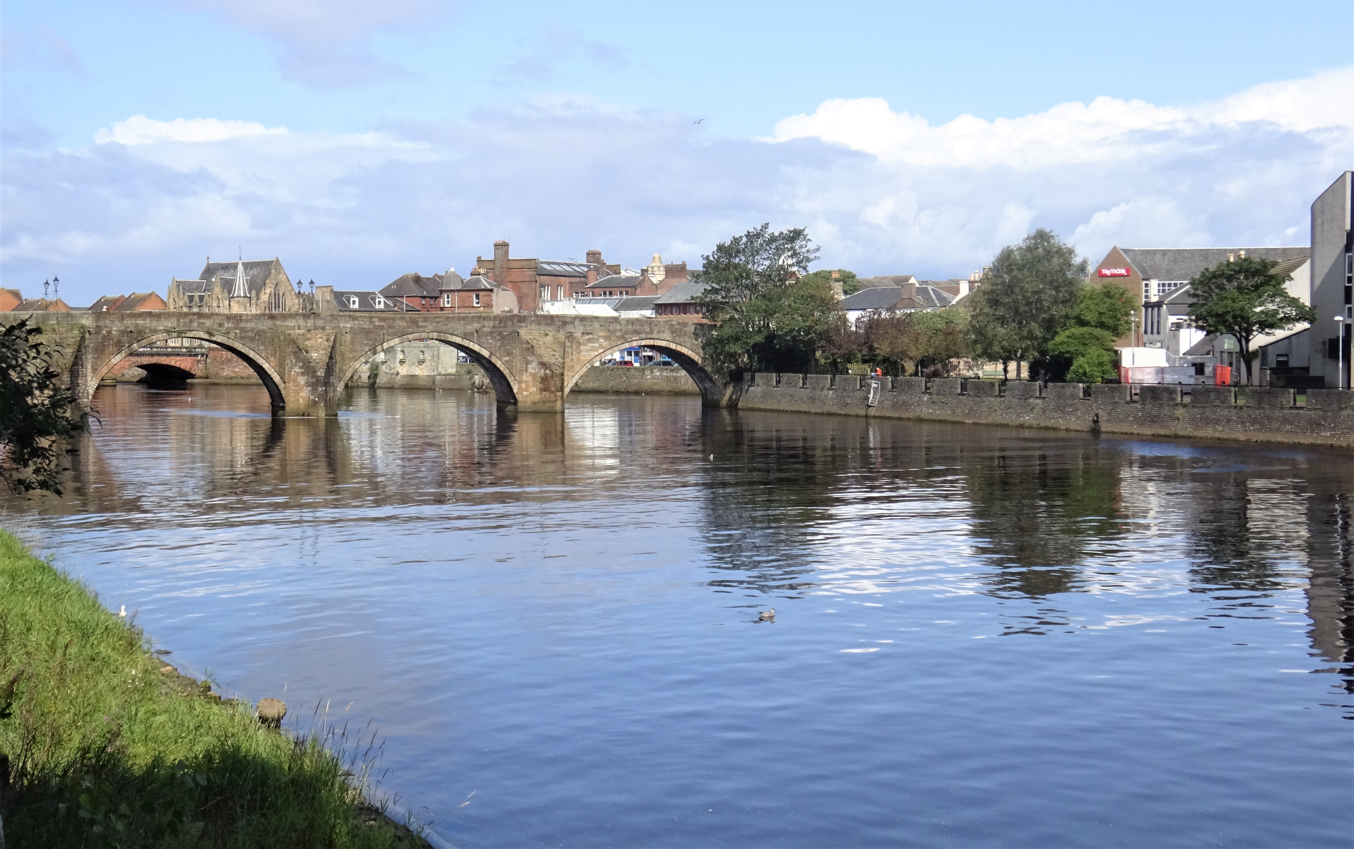
Image: Auld Brig of Ayr crossing the River Ayr on four low stone arches by Rosser1954 / Wikimedia Commons, licensed under CC BY-SA 4.0.

Ayr’s late-medieval river crossing survives as a four-arched pedestrian bridge: a working route, a landmark in Robert Burns’s The Brigs of Ayr, and the focus of an influential early conservation campaign.
Quick facts
- Date
- Built between about 1470 and 1525; repaired repeatedly; substantially restored 1907–1910
- Architect / designer
- Medieval builders not identified; 1907–1910 restoration by James A. Morris and W. S. Wilson
- Type
- Four-span stone pedestrian bridge
- Designation
- Listed building, Category A (LB21495)
- OS grid reference
- NS 33859 22113
Architecture
The bridge rises in a pronounced hogback profile over four segmental stone arches. Historic Environment Scotland describes coursed, squared sandstone, ringed by clear voussoirs, with cutwaters dividing the spans. Curved wing walls guide the approaches, while stepped coping follows the rise of the parapets and lamp standards punctuate the crossing.
Its fabric is cumulative rather than frozen at one date. Sixteenth- and seventeenth-century repairs and the major work of 1907–1910 are part of the structure now seen. Variations in masonry therefore record long use and repeated maintenance rather than a single untouched medieval campaign.
Its story
The statutory record dates construction broadly to 1470–1525 and notes the suggestion that a nearby ford served the High Street before the bridge was built. The Auld Brig then became one of Ayr’s defining crossings. Robert Burns turned the rivalry between the old and new bridges into dialogue in The Brigs of Ayr, imagining the older bridge would outlast its successor.
By the early twentieth century the Auld Brig required substantial intervention. A vigorous preservation campaign attracted national attention and a fundraising appeal associated with Lord Rosebery. James A. Morris and W. S. Wilson directed the 1907–1910 restoration, securing the bridge’s survival as a usable crossing rather than a detached monument.
Why it matters
The Auld Brig combines rare late-medieval bridge fabric with continuing civic use. Its four-arch form still shapes views along the River Ayr, while the Burns association and documented rescue campaign make the bridge part of Scotland’s literary and conservation history as well as its transport history.
What to notice
- The hogback rise of the deck and the sequence of four low segmental arches.
- The pointed cutwaters meeting the current and the curved wing walls at the approaches.
- Changes in colour, tooling and jointing that reveal repair campaigns within the sandstone fabric.
- The stepped parapet coping and later lamp standards, recently supplemented by new bridge lighting.
- How the bridge closes views from the river paths and links the historic town centre across the Ayr.
Current use and access
Historic Environment Scotland records the Auld Brig as still in use as a pedestrian crossing. South Ayrshire Council’s Ayr nature trail reaches the riverside immediately beside it, and the council records new lighting at the bridge among completed Ayr West projects. These sources establish public-realm exterior access and continuing pedestrian use; they do not guarantee a fully step-free route.
The deck is narrow and exposed, and approaches or adjacent river paths may be uneven, wet or slippery. Give other users room, dismount from cycles where necessary, and follow any temporary closure or maintenance notice on site. River levels, ice and severe weather can change conditions quickly.
Timeline
- Before the bridge A ford near the later crossing may have provided access towards Ayr High Street.
- 1470–1525 The present stone bridge was constructed within this broad date range.
- Sixteenth and seventeenth centuries Repeated repairs kept the crossing in service.
- Later eighteenth century Burns’s The Brigs of Ayr gave the old and new bridges a lasting literary identity.
- Early twentieth century A public campaign raised support for preservation.
- 1907–1910 James A. Morris and W. S. Wilson carried out the substantial restoration.
- Present The Auld Brig remains an active pedestrian crossing and a landmark on Ayr’s river paths.
What we know — and what remains uncertain
The statutory description securely records the bridge’s form, broad construction date and principal repair campaign, but it does not identify the medieval builders or assign surviving stones to every individual phase. The suggested earlier ford is an archaeological interpretation cited by Historic Environment Scotland rather than a precisely located structure. The bridge was removed from the schedule in 1998, but it remains designated as a Category A listed building.
Sources & further reading
- Historic Environment Scotland: Auld Brig over River Ayr, including lamp standards, LB21495 — Category, grid reference, construction range, fabric, repairs, restoration, Burns association and current pedestrian use.
- South Ayrshire Council: Ayr nature trail — Official walking-route context for the River Ayr path beside the Auld Brig.
- South Ayrshire Council: Ayr West capital projects — Current council record of completed lighting work at the Auld Brig.
Location
OS grid reference NS 33859 22113 · Location confidence: High: the statutory designation supplies an exact National Grid Reference and a current official or operator source confirms the place relationship. · Select the marker to open its satellite view in Google Maps. On desktop, drag Pegman (the yellow figure) onto a blue road. On mobile, turn on the Street View layer and tap a blue road. Other photo markers may be user-contributed.
Suggest a marker correction
Suggest a more accurate position
The teal marker is the current published position. The orange marker starts slightly to its right so both remain visible; this is only a visual starting position. Tap the correct place on the map or drag the orange marker. Sending this form creates a private review entry only; it does not move the published marker.
Check this area in Google Maps Choose the Satellite layer there if useful.
Map: © OpenStreetMap contributors. You can also enter checked coordinates below.